
 Mikhaylovka
Dyrestuy
Mikhaylovka
Mayskiy
Novobessergenevka
Tersky District
Lesnoy
Tertezh
Kuz'minskiye Otverzhki
Mikhaylovka
Dyrestuy
Mikhaylovka
Mayskiy
Novobessergenevka
Tersky District
Lesnoy
Tertezh
Kuz'minskiye Otverzhki
Rakovicheskoye Ozero on the map, Luga, Russian Federation
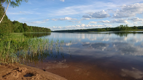
Photo
Where is located Rakovicheskoye Ozero
Rakovicheskoye Ozero — local attraction, which is located at no data and belongs to the category — -. Average visitor rating for this place — 4.7 (according to 74 ratings, information from open sources and relevant for 2022).
Exact location — Rakovicheskoye Ozero, marked on the map with a red marker.
You can get directions to Rakovicheskoye Ozero on the map from your location.
What else is interesting in Luga? You can see all the sights if you go to the city page.
Coordinates
Rakovicheskoye Ozero, Russian Federation coordinates in decimal format: latitude — 58.65291100244514, longitude — 29.822453793812013. When converted to degrees, minutes, seconds Rakovicheskoye Ozero has the following coordinates: 58°39′10.48 north latitude and 29°49′20.83 east longitude.
Nearby cities
The largest cities that are located nearby:
- Kolpino — 118 km
- Pskov — 135 km
- Saint Petersburg — 135 km
- Tartu
 (Estonia) — 185 km
 - Velikiye Luki — 268 km
- Tallinn (Estonia) — 297 km
- Helsinki
 (Finland) — 313 km
 - Vantaa (Finland) — 315 km
- Espoo (Finland) — 329 km
- Navapolatsk
 (Belarus) — 365 km
 - Daugavpils
 (Latvia) — 377 km
 - Rīga (Latvia) — 399 km
- Petrozavodsk — 411 km
- Tver — 421 km
- Tampere (Finland) — 443 km
- Turku (Finland) — 455 km
- Smolensk — 458 km
- Cherepovets — 459 km
- Panevėžys
 (Lithuania) — 476 km
Distance to the capital
Distance to the capital (Moscow) is about — 569 km.