
 Mikhaylovka
Dyrestuy
Mikhaylovka
Mayskiy
Novobessergenevka
Tersky District
Lesnoy
Tertezh
Kuz'minskiye Otverzhki
Mikhaylovka
Dyrestuy
Mikhaylovka
Mayskiy
Novobessergenevka
Tersky District
Lesnoy
Tertezh
Kuz'minskiye Otverzhki
MBU «Pechorskij istoriko-kraevedcheskij muzej» on the map, Pechora, Russian Federation
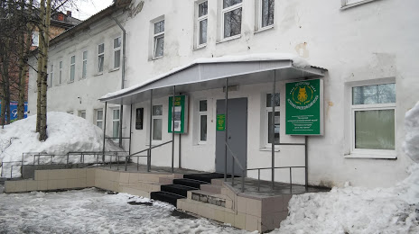
Photo
Where is located MBU «Pechorskij istoriko-kraevedcheskij muzej»
MBU «Pechorskij istoriko-kraevedcheskij muzej» — local attraction, which is located at Ulitsa Sovetskaya, 33, Pechora, Komi Republic, 169601 and belongs to the category — museum. Average visitor rating for this place — 4.5 (according to 60 ratings, information from open sources and relevant for 2022).
Exact location — MBU «Pechorskij istoriko-kraevedcheskij muzej», marked on the map with a red marker.
You can get directions to MBU «Pechorskij istoriko-kraevedcheskij muzej» on the map from your location.
What else is interesting in Pechora? You can see all the sights if you go to the city page.
Coordinates
MBU «Pechorskij istoriko-kraevedcheskij muzej», Russian Federation coordinates in decimal format: latitude — 65.14789154784461, longitude — 57.223559098839026. When converted to degrees, minutes, seconds MBU «Pechorskij istoriko-kraevedcheskij muzej» has the following coordinates: 65°8′52.41 north latitude and 57°13′24.81 east longitude.
Nearby cities
The largest cities that are located nearby:
- Ukhta — 245 km
- Syktyvkar — 510 km
- Solikamsk — 608 km
- Berezniki — 633 km
- Perm — 790 km
- Arkhangelsk — 794 km
- Glazov — 818 km
- Severodvinsk — 826 km
- Kirov — 843 km
- Pervouralsk — 923 km
- Nefteyugansk — 935 km
- Yekaterinburg — 940 km
- Izhevsk — 950 km
- Surgut — 963 km
- Sarapul — 981 km
- Tyumen — 1012 km
- Neftekamsk — 1015 km
- Yoshkar-Ola — 1098 km
- Nizhnekamsk — 1103 km
Distance to the capital
Distance to the capital (Moscow) is about — 1487 km.