
 Mikhaylovka
Dyrestuy
Mikhaylovka
Mayskiy
Novobessergenevka
Tersky District
Lesnoy
Tertezh
Kuz'minskiye Otverzhki
Mikhaylovka
Dyrestuy
Mikhaylovka
Mayskiy
Novobessergenevka
Tersky District
Lesnoy
Tertezh
Kuz'minskiye Otverzhki
Belgorodskaya Cherta on the map, Belgorod, Russian Federation
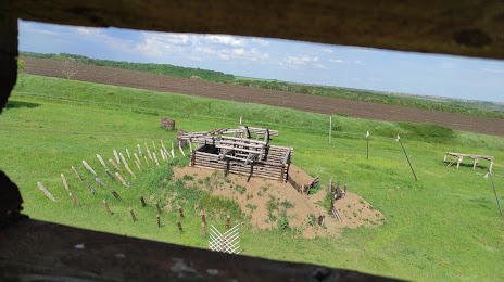
Photo
Where is located Belgorodskaya Cherta
Belgorodskaya Cherta — local attraction, which is located at Pushkarnoye, Belgorod Oblast, 308513 and belongs to the category — tourist attraction. Average visitor rating for this place — 4.9 (according to 9 ratings, information from open sources and relevant for 2022).
Exact location — Belgorodskaya Cherta, marked on the map with a red marker.
You can get directions to Belgorodskaya Cherta on the map from your location.
What else is interesting in Belgorod? You can see all the sights if you go to the city page.
Coordinates
Belgorodskaya Cherta, Russian Federation coordinates in decimal format: latitude — 50.664004276247724, longitude — 36.38356669810565. When converted to degrees, minutes, seconds Belgorodskaya Cherta has the following coordinates: 50°39′50.42 north latitude and 36°23′0.84 east longitude.
Nearby cities
The largest cities that are located nearby:
- Kursk — 126 km
- Sumy
 (Ukraine) — 130 km
 - Poltava (Ukraine) — 184 km
- Voronezh — 215 km
- Pavlohrad (Ukraine) — 236 km
- Yelets — 257 km
- Dniprodzerzhyns'k (Ukraine) — 272 km
- Horlivka
 — 274 km
 - Alchevs'k — 285 km
- Kremenchuk (Ukraine) — 287 km
- Luhansk — 299 km
- Donetsk — 299 km
- Lipetsk — 300 km
- Bryansk — 328 km
- Cherkasy (Ukraine) — 350 km
- Nikopol' (Ukraine) — 373 km
- Chernihiv (Ukraine) — 379 km
- Kryvyi Rih (Ukraine) — 381 km
- Kirovohrad (Ukraine) — 393 km
Distance to the capital
Distance to the capital (Moscow) is about — 572 km.