
 Mikhaylovka
Dyrestuy
Mikhaylovka
Mayskiy
Novobessergenevka
Tersky District
Lesnoy
Tertezh
Kuz'minskiye Otverzhki
Mikhaylovka
Dyrestuy
Mikhaylovka
Mayskiy
Novobessergenevka
Tersky District
Lesnoy
Tertezh
Kuz'minskiye Otverzhki
Gorodishche Ruzskiy Kreml' on the map, Ruza, Russian Federation
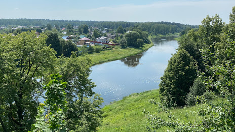
Photo
Where is located Gorodishche Ruzskiy Kreml'
Gorodishche Ruzskiy Kreml' — local attraction, which is located at Ulitsa Parkovaya, Ruza, Moscow Oblast, 143103 and belongs to the category — museum. Average visitor rating for this place — 4.3 (according to 77 ratings, information from open sources and relevant for 2022).
Exact location — Gorodishche Ruzskiy Kreml', marked on the map with a red marker.
You can get directions to Gorodishche Ruzskiy Kreml' on the map from your location.
What else is interesting in Ruza? You can see all the sights if you go to the city page.
Coordinates
Gorodishche Ruzskiy Kreml', Russian Federation coordinates in decimal format: latitude — 55.69802474913032, longitude — 36.19030999829494. When converted to degrees, minutes, seconds Gorodishche Ruzskiy Kreml' has the following coordinates: 55°41′52.89 north latitude and 36°11′25.12 east longitude.
Nearby cities
The largest cities that are located nearby:
- Odintsovo — 67 km
- Obninsk — 69 km
- Zelenograd — 70 km
- Khimki — 80 km
- Podolsk — 90 km
- Izmaylovo — 91 km
- Lyubertsy — 106 km
- Pushkino — 106 km
- Balashikha — 111 km
- Serpukhov — 116 km
- Kaluga — 127 km
- Tver — 129 km
- Elektrostal — 141 km
- Noginsk — 142 km
- Orekhovo-Zuyevo — 172 km
- Kolomna — 176 km
- Tula — 189 km
- Novomoskovsk — 231 km
- Ryazan — 255 km
Distance to the capital
Distance to the capital (Moscow) is about — 90 km.