
 Mikhaylovka
Dyrestuy
Mikhaylovka
Mayskiy
Novobessergenevka
Tersky District
Lesnoy
Tertezh
Kuz'minskiye Otverzhki
Mikhaylovka
Dyrestuy
Mikhaylovka
Mayskiy
Novobessergenevka
Tersky District
Lesnoy
Tertezh
Kuz'minskiye Otverzhki
Atamanskiy Dvorets on the map, Novocherkassk, Russian Federation
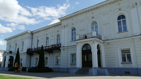
Photo
Where is located Atamanskiy Dvorets
Atamanskiy Dvorets — local attraction, which is located at Dvortsovaya Ulitsa, 5 А, Novocherkassk, Rostov Oblast, 346400 and belongs to the category — official residence. Average visitor rating for this place — 4.6 (according to 189 ratings, information from open sources and relevant for 2022).
Exact location — Atamanskiy Dvorets, marked on the map with a red marker.
You can get directions to Atamanskiy Dvorets on the map from your location.
What else is interesting in Novocherkassk? You can see all the sights if you go to the city page.
Coordinates
Atamanskiy Dvorets, Russian Federation coordinates in decimal format: latitude — 47.4093939752034, longitude — 40.101578197990186. When converted to degrees, minutes, seconds Atamanskiy Dvorets has the following coordinates: 47°24′33.82 north latitude and 40°6′5.68 east longitude.
Nearby cities
The largest cities that are located nearby:
- Shakhty — 33 km
- Bataysk — 40 km
- Taganrog — 90 km
- Luhansk
 — 140 km
 - Alchevs'k — 150 km
- Volgodonsk — 157 km
- Horlivka — 180 km
- Donetsk — 181 km
- Berdyans'k — 260 km
- Krasnodar — 278 km
- Stavropol — 301 km
- Maykop — 311 km
- Pavlohrad
 (Ukraine) — 332 km
 - Nevinnomyssk — 340 km
- Elista — 342 km
- Novorossiysk — 350 km
- Volgograd — 353 km
- Kerch — 362 km
- Melitopol' — 363 km
Distance to the capital
Distance to the capital (Moscow) is about — 944 km.