
 Mikhaylovka
Dyrestuy
Mikhaylovka
Mayskiy
Novobessergenevka
Tersky District
Lesnoy
Tertezh
Kuz'minskiye Otverzhki
Mikhaylovka
Dyrestuy
Mikhaylovka
Mayskiy
Novobessergenevka
Tersky District
Lesnoy
Tertezh
Kuz'minskiye Otverzhki
Plaza on the map, Blagoveshchensk, Russian Federation
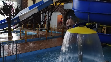
Photo
Where is located Plaza
Plaza — local attraction, which is located at Zavodskaya Ulitsa, 154, Blagoveshchensk, Amur Oblast, 675029 and belongs to the category — water park. Average visitor rating for this place — 4.4 (according to 1187 ratings, information from open sources and relevant for 2022).
Exact location — Plaza, marked on the map with a red marker.
You can get directions to Plaza on the map from your location.
What else is interesting in Blagoveshchensk? You can see all the sights if you go to the city page.
Coordinates
Plaza, Russian Federation coordinates in decimal format: latitude — 50.28491090242142, longitude — 127.51721619809197. When converted to degrees, minutes, seconds Plaza has the following coordinates: 50°17′5.68 north latitude and 127°31′1.98 east longitude.
Nearby cities
The largest cities that are located nearby:
- Heihe
 (China) — 3 km
 - Hegang (China) — 384 km
- Suihua (China) — 402 km
- Qiqihar (China) — 422 km
- Jiamusi (China) — 438 km
- Daqing (China) — 447 km
- Harbin (China) — 500 km
- Khabarovsk — 585 km
- Jixi (China) — 612 km
- Mudanjiang (China) — 654 km
- Komsomolsk-on-Amur — 665 km
- Jilin (China) — 716 km
- Changchun (China) — 735 km
- Ussuriysk — 798 km
- Siping (China) — 827 km
- Liaoyuan (China) — 839 km
- Tongliao (China) — 846 km
- Artem — 850 km
- Vladivostok — 864 km
Distance to the capital
Distance to the capital (Moscow) is about — 5613 km.