
 Mikhaylovka
Dyrestuy
Mikhaylovka
Mayskiy
Novobessergenevka
Tersky District
Lesnoy
Tertezh
Kuz'minskiye Otverzhki
Mikhaylovka
Dyrestuy
Mikhaylovka
Mayskiy
Novobessergenevka
Tersky District
Lesnoy
Tertezh
Kuz'minskiye Otverzhki
Syzran Kremlin on the map, Syzran, Russian Federation
Photo
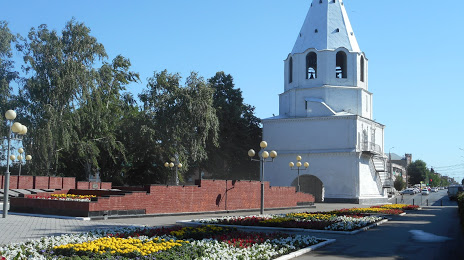
Where is located Syzran Kremlin
Syzran Kremlin — local attraction, which is located at Sovetskaya Ulitsa, 2А, Syzran, Samara Oblast, 446001 and belongs to the category — tourist attraction. Average visitor rating for this place — 4.6 (according to 1724 ratings, information from open sources and relevant for 2022).
Exact location — Syzran Kremlin, marked on the map with a red marker.
You can get directions to Syzran Kremlin on the map from your location.
What else is interesting in Syzran? You can see all the sights if you go to the city page.
Coordinates
Syzran Kremlin, Russian Federation coordinates in decimal format: latitude — 53.14682290596752, longitude — 48.45429889819746. When converted to degrees, minutes, seconds Syzran Kremlin has the following coordinates: 53°8′48.56 north latitude and 48°27′15.48 east longitude.
Nearby cities
The largest cities that are located nearby:
- Tolyatti — 73 km
- Novokuybyshevsk — 98 km
- Samara — 111 km
- Ulyanovsk — 127 km
- Balakovo — 134 km
- Dimitrovgrad — 137 km
- Penza — 229 km
- Saransk — 240 km
- Engels — 245 km
- Saratov — 247 km
- Kazan — 293 km
- Zelenodolsk — 297 km
- Almetyevsk — 311 km
- Novocheboksarsk — 330 km
- Cheboksary — 338 km
- Nizhnekamsk — 344 km
- Arzamas — 382 km
- Yoshkar-Ola — 385 km
- Kamyshin — 404 km
Distance to the capital
Distance to the capital (Moscow) is about — 757 km.