
 Mikhaylovka
Dyrestuy
Mikhaylovka
Mayskiy
Novobessergenevka
Tersky District
Lesnoy
Tertezh
Kuz'minskiye Otverzhki
Mikhaylovka
Dyrestuy
Mikhaylovka
Mayskiy
Novobessergenevka
Tersky District
Lesnoy
Tertezh
Kuz'minskiye Otverzhki
Rossiyskiy Gosudarstvennyy Muzey Arktiki I Antarktiki on the map, Metallostroy, Russian Federation
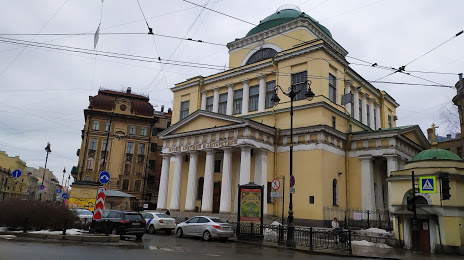
Photo
Where is located Rossiyskiy Gosudarstvennyy Muzey Arktiki I Antarktiki
Rossiyskiy Gosudarstvennyy Muzey Arktiki I Antarktiki — local attraction, which is located at Ul. Marata, 24А, St Petersburg, 191040 and belongs to the category — museum. Average visitor rating for this place — 4.6 (according to 2345 ratings, information from open sources and relevant for 2022).
Exact location — Rossiyskiy Gosudarstvennyy Muzey Arktiki I Antarktiki, marked on the map with a red marker.
You can get directions to Rossiyskiy Gosudarstvennyy Muzey Arktiki I Antarktiki on the map from your location.
What else is interesting in Metallostroy? You can see all the sights if you go to the city page.
Coordinates
Rossiyskiy Gosudarstvennyy Muzey Arktiki I Antarktiki, Russian Federation coordinates in decimal format: latitude — 59.92748590101819, longitude — 30.353571998463057. When converted to degrees, minutes, seconds Rossiyskiy Gosudarstvennyy Muzey Arktiki I Antarktiki has the following coordinates: 59°55′38.95 north latitude and 30°21′12.86 east longitude.
Nearby cities
The largest cities that are located nearby:
- Kolpino — 8 km
- Saint Petersburg — 19 km
- Pskov — 255 km
- Tartu
 (Estonia) — 272 km
 - Petrozavodsk — 295 km
- Vantaa
 (Finland) — 307 km
 - Helsinki (Finland) — 311 km
- Espoo (Finland) — 327 km
- Tallinn (Estonia) — 328 km
- Velikiye Luki — 383 km
- Tampere (Finland) — 404 km
- Cherepovets — 424 km
- Turku (Finland) — 457 km
- Tver — 459 km
- Navapolatsk
 (Belarus) — 490 km
 - Daugavpils
 (Latvia) — 500 km
 - Rīga (Latvia) — 500 km
- Rybinsk — 522 km
- Vologda — 533 km
Distance to the capital
Distance to the capital (Moscow) is about — 632 km.