
 Mikhaylovka
Dyrestuy
Mikhaylovka
Mayskiy
Novobessergenevka
Tersky District
Lesnoy
Tertezh
Kuz'minskiye Otverzhki
Mikhaylovka
Dyrestuy
Mikhaylovka
Mayskiy
Novobessergenevka
Tersky District
Lesnoy
Tertezh
Kuz'minskiye Otverzhki
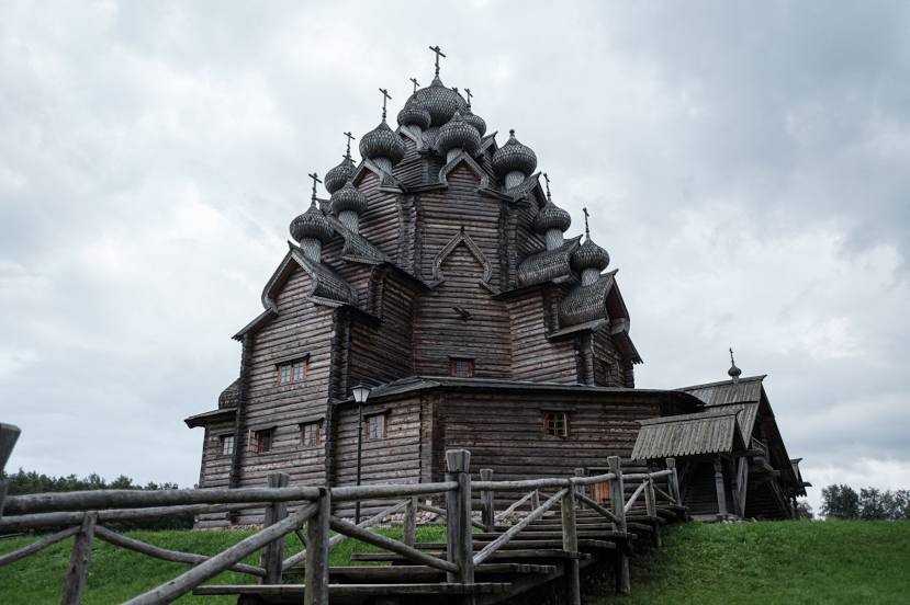
Tserkov' Pokrova Presvyatoy Bogoroditsy V Usad'be Bogoslovka on the map, Kolpino, Russian Federation
Photo
Where is located Tserkov' Pokrova Presvyatoy Bogoroditsy V Usad'be Bogoslovka
Tserkov' Pokrova Presvyatoy Bogoroditsy V Usad'be Bogoslovka — local attraction, which is located at Погост Покровской церкви, 1 Усадьба "Богословка, Leningrad Oblast, 188683 and belongs to the category — orthodox church. Average visitor rating for this place — 4.8 (according to 1400 ratings, information from open sources and relevant for 2022).
Exact location — Tserkov' Pokrova Presvyatoy Bogoroditsy V Usad'be Bogoslovka, marked on the map with a red marker.
You can get directions to Tserkov' Pokrova Presvyatoy Bogoroditsy V Usad'be Bogoslovka on the map from your location.
What else is interesting in Kolpino? You can see all the sights if you go to the city page.
Coordinates
Tserkov' Pokrova Presvyatoy Bogoroditsy V Usad'be Bogoslovka, Russian Federation coordinates in decimal format: latitude — 59.82683761947415, longitude — 30.569116198458907. When converted to degrees, minutes, seconds Tserkov' Pokrova Presvyatoy Bogoroditsy V Usad'be Bogoslovka has the following coordinates: 59°49′36.62 north latitude and 30°34′8.82 east longitude.
Nearby cities
The largest cities that are located nearby:
- Saint Petersburg — 27 km
- Pskov — 250 km
- Tartu
 (Estonia) — 270 km
 - Petrozavodsk — 299 km
- Vantaa
 (Finland) — 311 km
 - Helsinki (Finland) — 315 km
- Tallinn (Estonia) — 330 km
- Espoo (Finland) — 331 km
- Velikiye Luki — 375 km
- Tampere (Finland) — 410 km
- Cherepovets — 420 km
- Tver — 452 km
- Turku (Finland) — 461 km
- Navapolatsk
 (Belarus) — 484 km
 - Daugavpils
 (Latvia) — 496 km
 - Rīga (Latvia) — 498 km
- Rybinsk — 516 km
- Vologda — 529 km
- Smolensk — 554 km
Distance to the capital
Distance to the capital (Moscow) is about — 615 km.