
 Mikhaylovka
Dyrestuy
Mikhaylovka
Mayskiy
Novobessergenevka
Tersky District
Lesnoy
Tertezh
Kuz'minskiye Otverzhki
Mikhaylovka
Dyrestuy
Mikhaylovka
Mayskiy
Novobessergenevka
Tersky District
Lesnoy
Tertezh
Kuz'minskiye Otverzhki
History and Art Museum on the map, Roslavl, Russian Federation
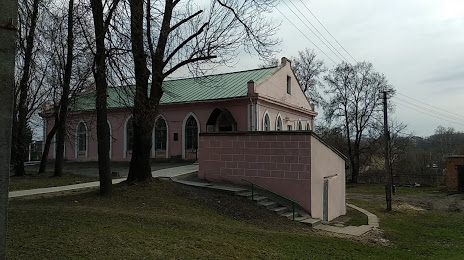
Photo
Where is located History and Art Museum
History and Art Museum — local attraction, which is located at Ulitsa Proletarskaya, 63, Roslavl, Smolensk Oblast, 216500 and belongs to the category — museum. Average visitor rating for this place — 4.7 (according to 38 ratings, information from open sources and relevant for 2022).
Exact location — History and Art Museum, marked on the map with a red marker.
You can get directions to History and Art Museum on the map from your location.
What else is interesting in Roslavl? You can see all the sights if you go to the city page.
Coordinates
History and Art Museum, Russian Federation coordinates in decimal format: latitude — 53.95364591376445, longitude — 32.86354669822795. When converted to degrees, minutes, seconds History and Art Museum has the following coordinates: 53°57′13.13 north latitude and 32°51′48.77 east longitude.
Nearby cities
The largest cities that are located nearby:
- Smolensk — 106 km
- Bryansk — 128 km
- Gomel
 (Belarus) — 210 km
 - Kaluga — 229 km
- Babruysk (Belarus) — 258 km
- Obninsk — 269 km
- Chernihiv
 (Ukraine) — 292 km
 - Velikiye Luki — 300 km
- Tula — 309 km
- Serpukhov — 309 km
- Navapolatsk (Belarus) — 320 km
- Mazyr (Belarus) — 326 km
- Odintsovo — 334 km
- Kursk — 335 km
- Podolsk — 336 km
- Minsk (Belarus) — 345 km
- Izmaylovo — 348 km
- Zelenograd — 350 km
- Novomoskovsk — 353 km
Distance to the capital
Distance to the capital (Moscow) is about — 364 km.