
 Mikhaylovka
Dyrestuy
Mikhaylovka
Mayskiy
Novobessergenevka
Tersky District
Lesnoy
Tertezh
Kuz'minskiye Otverzhki
Mikhaylovka
Dyrestuy
Mikhaylovka
Mayskiy
Novobessergenevka
Tersky District
Lesnoy
Tertezh
Kuz'minskiye Otverzhki
Gora Krestovaya on the map, Kandalaksha, Russian Federation
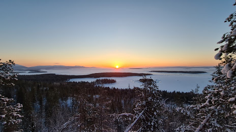
Photo
Where is located Gora Krestovaya
Gora Krestovaya — local attraction, which is located at Kandalaksha, Murmansk Oblast, 184042 and belongs to the category — ski resort. Average visitor rating for this place — 4.7 (according to 109 ratings, information from open sources and relevant for 2022).
Exact location — Gora Krestovaya, marked on the map with a red marker.
You can get directions to Gora Krestovaya on the map from your location.
What else is interesting in Kandalaksha? You can see all the sights if you go to the city page.
Coordinates
Gora Krestovaya, Russian Federation coordinates in decimal format: latitude — 67.13270994812375, longitude — 32.4659481954459. When converted to degrees, minutes, seconds Gora Krestovaya has the following coordinates: 67°7′57.76 north latitude and 32°27′57.41 east longitude.
Nearby cities
The largest cities that are located nearby:
- Oulu
 (Finland) — 401 km
 - Severodvinsk — 455 km
- Arkhangelsk — 483 km
- Petrozavodsk — 602 km
- Tampere (Finland) — 773 km
- Saint Petersburg — 806 km
- Kolpino — 826 km
- Vantaa (Finland) — 859 km
- Helsinki (Finland) — 874 km
- Espoo (Finland) — 878 km
- Turku (Finland) — 924 km
- Cherepovets — 940 km
- Tallinn
 (Estonia) — 955 km
 - Vologda — 974 km
- Tartu (Estonia) — 1024 km
- Pskov — 1059 km
- Rybinsk — 1074 km
- Ukhta — 1121 km
- Syktyvkar — 1141 km
Distance to the capital
Distance to the capital (Moscow) is about — 1294 km.