
 Mikhaylovka
Dyrestuy
Mikhaylovka
Mayskiy
Novobessergenevka
Tersky District
Lesnoy
Tertezh
Kuz'minskiye Otverzhki
Mikhaylovka
Dyrestuy
Mikhaylovka
Mayskiy
Novobessergenevka
Tersky District
Lesnoy
Tertezh
Kuz'minskiye Otverzhki
Yelabuzhskiy Kazansko-Bogoroditskiy Monastyr' on the map, Yelabuga, Russian Federation
Photo
Where is located Yelabuzhskiy Kazansko-Bogoroditskiy Monastyr'
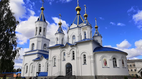
Yelabuzhskiy Kazansko-Bogoroditskiy Monastyr' — local attraction, which is located at Ulitsa Maksima Gor'kogo, 119, Yelabuga, Republic of Tatarstan, 423604 and belongs to the category — convent. Average visitor rating for this place — 4.7 (according to 114 ratings, information from open sources and relevant for 2022).
Exact location — Yelabuzhskiy Kazansko-Bogoroditskiy Monastyr', marked on the map with a red marker.
You can get directions to Yelabuzhskiy Kazansko-Bogoroditskiy Monastyr' on the map from your location.
What else is interesting in Yelabuga? You can see all the sights if you go to the city page.
Coordinates
Yelabuzhskiy Kazansko-Bogoroditskiy Monastyr', Russian Federation coordinates in decimal format: latitude — 55.7617002984147, longitude — 52.07965699829738. When converted to degrees, minutes, seconds Yelabuzhskiy Kazansko-Bogoroditskiy Monastyr' has the following coordinates: 55°45′42.12 north latitude and 52°4′46.77 east longitude.
Nearby cities
The largest cities that are located nearby:
- Nizhnekamsk — 22 km
- Almetyevsk — 98 km
- Sarapul — 130 km
- Izhevsk — 135 km
- Neftekamsk — 141 km
- Kazan — 183 km
- Zelenodolsk — 222 km
- Dimitrovgrad — 235 km
- Glazov — 264 km
- Ufa — 273 km
- Yoshkar-Ola — 274 km
- Novocheboksarsk — 285 km
- Ulyanovsk — 288 km
- Cheboksary — 302 km
- Tolyatti — 305 km
- Samara — 311 km
- Novokuybyshevsk — 328 km
- Kirov — 343 km
- Sterlitamak — 346 km
Distance to the capital
Distance to the capital (Moscow) is about — 903 km.