
 Mikhaylovka
Dyrestuy
Mikhaylovka
Mayskiy
Novobessergenevka
Tersky District
Lesnoy
Tertezh
Kuz'minskiye Otverzhki
Mikhaylovka
Dyrestuy
Mikhaylovka
Mayskiy
Novobessergenevka
Tersky District
Lesnoy
Tertezh
Kuz'minskiye Otverzhki
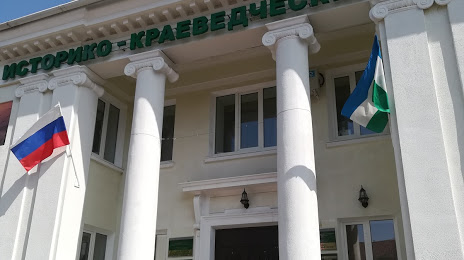
Salavatskiy Istoriko-Krayevedcheskiy Muzey on the map, Salavat, Russian Federation
Photo
Where is located Salavatskiy Istoriko-Krayevedcheskiy Muzey
Salavatskiy Istoriko-Krayevedcheskiy Muzey — local attraction, which is located at Ulitsa Pervomayskaya, 18, Salavat, Republic of Bashkortostan, 453261 and belongs to the category — museum. Average visitor rating for this place — 4.4 (according to 113 ratings, information from open sources and relevant for 2022).
Exact location — Salavatskiy Istoriko-Krayevedcheskiy Muzey, marked on the map with a red marker.
You can get directions to Salavatskiy Istoriko-Krayevedcheskiy Muzey on the map from your location.
What else is interesting in Salavat? You can see all the sights if you go to the city page.
Coordinates
Salavatskiy Istoriko-Krayevedcheskiy Muzey, Russian Federation coordinates in decimal format: latitude — 53.36670227097837, longitude — 55.925808398205625. When converted to degrees, minutes, seconds Salavatskiy Istoriko-Krayevedcheskiy Muzey has the following coordinates: 53°22′0.13 north latitude and 55°55′32.91 east longitude.
Nearby cities
The largest cities that are located nearby:
- Sterlitamak — 29 km
- Ufa — 152 km
- Orenburg — 186 km
- Magnitogorsk — 202 km
- Almetyevsk — 285 km
- Novotroitsk — 290 km
- Orsk — 301 km
- Zlatoust — 309 km
- Neftekamsk — 319 km
- Miass — 320 km
- Nizhnekamsk — 359 km
- Sarapul — 367 km
- Samara — 384 km
- Novokuybyshevsk — 399 km
- Chelyabinsk — 400 km
- Izhevsk — 418 km
- Dimitrovgrad — 422 km
- Tolyatti — 429 km
- Pervouralsk — 461 km
Distance to the capital
Distance to the capital (Moscow) is about — 1206 km.