
 Mikhaylovka
Dyrestuy
Mikhaylovka
Mayskiy
Novobessergenevka
Tersky District
Lesnoy
Tertezh
Kuz'minskiye Otverzhki
Mikhaylovka
Dyrestuy
Mikhaylovka
Mayskiy
Novobessergenevka
Tersky District
Lesnoy
Tertezh
Kuz'minskiye Otverzhki
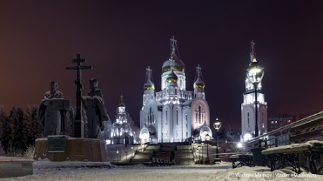
Kafedral'nyy Sobor Voskreseniya Khristova on the map, Khanty-Mansiysk, Russian Federation
Photo
Where is located Kafedral'nyy Sobor Voskreseniya Khristova
Kafedral'nyy Sobor Voskreseniya Khristova — local attraction, which is located at Ulitsa Gagarina, 9, Khanty-Mansiysk, Khanty-Mansi Autonomous Okrug, 628011 and belongs to the category — cathedral. Average visitor rating for this place — 4.8 (according to 517 ratings, information from open sources and relevant for 2022).
Exact location — Kafedral'nyy Sobor Voskreseniya Khristova, marked on the map with a red marker.
You can get directions to Kafedral'nyy Sobor Voskreseniya Khristova on the map from your location.
What else is interesting in Khanty-Mansiysk? You can see all the sights if you go to the city page.
Coordinates
Kafedral'nyy Sobor Voskreseniya Khristova, Russian Federation coordinates in decimal format: latitude — 60.998121973532214, longitude — 69.02520799850679. When converted to degrees, minutes, seconds Kafedral'nyy Sobor Voskreseniya Khristova has the following coordinates: 60°59′53.24 north latitude and 69°1′30.75 east longitude.
Nearby cities
The largest cities that are located nearby:
- Nefteyugansk — 190 km
- Surgut — 235 km
- Nizhnevartovsk — 403 km
- Tyumen — 475 km
- Kurgan — 655 km
- Yekaterinburg — 687 km
- Solikamsk — 703 km
- Pervouralsk — 711 km
- Berezniki — 712 km
- Omsk — 721 km
- Chelyabinsk — 805 km
- Ukhta — 806 km
- Perm — 816 km
- Kokshetau
 (Kazakhstan) — 853 km
 - Miass — 873 km
- Zlatoust — 876 km
- Kostanay (Kazakhstan) — 932 km
- Syktyvkar — 959 km
- Glazov — 1007 km
Distance to the capital
Distance to the capital (Moscow) is about — 1901 km.