
 Mikhaylovka
Dyrestuy
Mikhaylovka
Mayskiy
Novobessergenevka
Tersky District
Lesnoy
Tertezh
Kuz'minskiye Otverzhki
Mikhaylovka
Dyrestuy
Mikhaylovka
Mayskiy
Novobessergenevka
Tersky District
Lesnoy
Tertezh
Kuz'minskiye Otverzhki
Park Imeni 50-Letiya Sovetskoy Vlasti on the map, Murom, Russian Federation
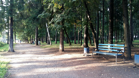
Photo
Where is located Park Imeni 50-Letiya Sovetskoy Vlasti
Park Imeni 50-Letiya Sovetskoy Vlasti — local attraction, which is located at Vladimirskoye sh., 8а, Murom, Vladimir Oblast, 602256 and belongs to the category — park. Average visitor rating for this place — 4.6 (according to 1756 ratings, information from open sources and relevant for 2022).
Exact location — Park Imeni 50-Letiya Sovetskoy Vlasti, marked on the map with a red marker.
You can get directions to Park Imeni 50-Letiya Sovetskoy Vlasti on the map from your location.
What else is interesting in Murom? You can see all the sights if you go to the city page.
Coordinates
Park Imeni 50-Letiya Sovetskoy Vlasti, Russian Federation coordinates in decimal format: latitude — 55.578105056415225, longitude — 42.02233419829028. When converted to degrees, minutes, seconds Park Imeni 50-Letiya Sovetskoy Vlasti has the following coordinates: 55°34′41.18 north latitude and 42°1′20.4 east longitude.
Nearby cities
The largest cities that are located nearby:
- Kovrov — 98 km
- Arzamas — 113 km
- Dzerzhinsk — 114 km
- Vladimir — 118 km
- Ryazan — 182 km
- Orekhovo-Zuyevo — 192 km
- Kolomna — 213 km
- Elektrostal — 223 km
- Noginsk — 224 km
- Kostroma — 252 km
- Balashikha — 254 km
- Saransk — 255 km
- Lyubertsy — 258 km
- Yaroslavl — 261 km
- Pushkino — 264 km
- Izmaylovo — 275 km
- Podolsk — 282 km
- Khimki — 287 km
- Odintsovo — 297 km
Distance to the capital
Distance to the capital (Moscow) is about — 277 km.