
 Mikhaylovka
Dyrestuy
Mikhaylovka
Mayskiy
Novobessergenevka
Tersky District
Lesnoy
Tertezh
Kuz'minskiye Otverzhki
Mikhaylovka
Dyrestuy
Mikhaylovka
Mayskiy
Novobessergenevka
Tersky District
Lesnoy
Tertezh
Kuz'minskiye Otverzhki
Kerchenskiy Istoriko Arkheologicheskiy Muzey on the map, Kerch, Crimea
Photo
Where is located Kerchenskiy Istoriko Arkheologicheskiy Muzey
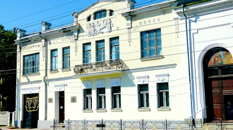
Kerchenskiy Istoriko Arkheologicheskiy Muzey — local attraction, which is located at Aivazovs'koho St, Kerch and belongs to the category — museum. Average visitor rating for this place — 4.6 (according to 472 ratings, information from open sources and relevant for 2022).
Exact location — Kerchenskiy Istoriko Arkheologicheskiy Muzey, marked on the map with a red marker.
You can get directions to Kerchenskiy Istoriko Arkheologicheskiy Muzey on the map from your location.
What else is interesting in Kerch? You can see all the sights if you go to the city page.
Coordinates
Kerchenskiy Istoriko Arkheologicheskiy Muzey coordinates in decimal format: latitude — 45.34767117545597, longitude — 36.470576698078496. When converted to degrees, minutes, seconds Kerchenskiy Istoriko Arkheologicheskiy Muzey has the following coordinates: 45°20′51.62 north latitude and 36°28′14.08 east longitude.
Nearby cities
The largest cities that are located nearby:
- Novorossiysk — 123 km
- Berdyans'k
 — 157 km
 - Melitopol' — 183 km
- Simferopol — 190 km
- Krasnodar — 198 km
- Yevpatoriya — 242 km
- Sevastopol — 246 km
- Taganrog — 276 km
- Nikopol'
 (Ukraine) — 289 km
 - Maykop — 297 km
- Donetsk — 310 km
- Bataysk — 315 km
- Kherson — 325 km
- Sochi — 326 km
- Horlivka — 346 km
- Pavlohrad (Ukraine) — 352 km
- Novocherkassk — 354 km
- Kryvyi Rih (Ukraine) — 363 km
- Dniprodzerzhyns'k (Ukraine) — 375 km
Distance to the capital
Distance to the capital (Moscow) is about — 1160 km.