
 Mikhaylovka
Dyrestuy
Mikhaylovka
Mayskiy
Novobessergenevka
Tersky District
Lesnoy
Tertezh
Kuz'minskiye Otverzhki
Mikhaylovka
Dyrestuy
Mikhaylovka
Mayskiy
Novobessergenevka
Tersky District
Lesnoy
Tertezh
Kuz'minskiye Otverzhki
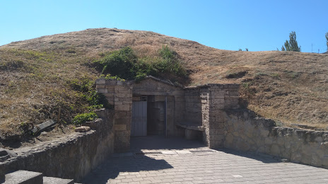
Melek-Chesmensky mound on the map, Kerch, Crimea
Photo
Where is located Melek-Chesmensky mound
Melek-Chesmensky mound — local attraction, which is located at Haidara St, Kerch and belongs to the category — museum. Average visitor rating for this place — 4.5 (according to 122 ratings, information from open sources and relevant for 2022).
Exact location — Melek-Chesmensky mound, marked on the map with a red marker.
You can get directions to Melek-Chesmensky mound on the map from your location.
What else is interesting in Kerch? You can see all the sights if you go to the city page.
Coordinates
Melek-Chesmensky mound coordinates in decimal format: latitude — 45.36313132705281, longitude — 36.47034819807897. When converted to degrees, minutes, seconds Melek-Chesmensky mound has the following coordinates: 45°21′47.27 north latitude and 36°28′13.25 east longitude.
Nearby cities
The largest cities that are located nearby:
- Novorossiysk — 123 km
- Berdyans'k
 — 157 km
 - Melitopol' — 183 km
- Simferopol — 190 km
- Krasnodar — 198 km
- Yevpatoriya — 242 km
- Sevastopol — 246 km
- Taganrog — 276 km
- Nikopol'
 (Ukraine) — 289 km
 - Maykop — 297 km
- Donetsk — 310 km
- Bataysk — 315 km
- Kherson — 325 km
- Sochi — 326 km
- Horlivka — 346 km
- Pavlohrad (Ukraine) — 352 km
- Novocherkassk — 354 km
- Kryvyi Rih (Ukraine) — 363 km
- Dniprodzerzhyns'k (Ukraine) — 375 km
Distance to the capital
Distance to the capital (Moscow) is about — 1159 km.