
 Mikhaylovka
Dyrestuy
Mikhaylovka
Mayskiy
Novobessergenevka
Tersky District
Lesnoy
Tertezh
Kuz'minskiye Otverzhki
Mikhaylovka
Dyrestuy
Mikhaylovka
Mayskiy
Novobessergenevka
Tersky District
Lesnoy
Tertezh
Kuz'minskiye Otverzhki
Novouralsk historical museum on the map, Novouralsk, Russian Federation
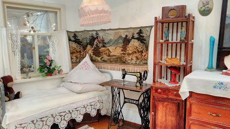
Photo
Where is located Novouralsk historical museum
Novouralsk historical museum — local attraction, which is located at Pervomayskaya Ulitsa, 5, Novouralsk, Sverdlovsk Oblast, 624131 and belongs to the category — local history museum. Average visitor rating for this place — 4.4 (according to 97 ratings, information from open sources and relevant for 2022).
Exact location — Novouralsk historical museum, marked on the map with a red marker.
You can get directions to Novouralsk historical museum on the map from your location.
What else is interesting in Novouralsk? You can see all the sights if you go to the city page.
Coordinates
Novouralsk historical museum, Russian Federation coordinates in decimal format: latitude — 57.25691435026198, longitude — 60.10268099851431. When converted to degrees, minutes, seconds Novouralsk historical museum has the following coordinates: 57°15′24.89 north latitude and 60°6′9.65 east longitude.
Nearby cities
The largest cities that are located nearby:
- Pervouralsk — 38 km
- Yekaterinburg — 55 km
- Zlatoust — 232 km
- Perm — 236 km
- Chelyabinsk — 246 km
- Miass — 249 km
- Berezniki — 303 km
- Solikamsk — 324 km
- Tyumen — 326 km
- Neftekamsk — 379 km
- Ufa — 382 km
- Kurgan — 385 km
- Sarapul — 393 km
- Izhevsk — 420 km
- Magnitogorsk — 430 km
- Glazov — 444 km
- Sterlitamak — 483 km
- Kostanay
 (Kazakhstan) — 504 km
 - Salavat — 509 km
Distance to the capital
Distance to the capital (Moscow) is about — 1384 km.