
 Mikhaylovka
Dyrestuy
Mikhaylovka
Mayskiy
Novobessergenevka
Tersky District
Lesnoy
Tertezh
Kuz'minskiye Otverzhki
Mikhaylovka
Dyrestuy
Mikhaylovka
Mayskiy
Novobessergenevka
Tersky District
Lesnoy
Tertezh
Kuz'minskiye Otverzhki
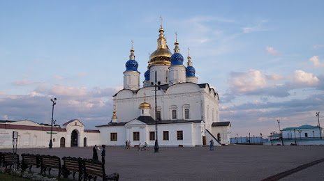
Sofiysko-Uspenskiy Kafedral'nyy Sobor on the map, Tobolsk, Russian Federation
Photo
Where is located Sofiysko-Uspenskiy Kafedral'nyy Sobor
Sofiysko-Uspenskiy Kafedral'nyy Sobor — local attraction, which is located at Ulitsa Krasnaya Ploshchad', 2, строение 21, Tobolsk, Tyumen Oblast, 626152 and belongs to the category — orthodox church. Average visitor rating for this place — 4.9 (according to 52 ratings, information from open sources and relevant for 2022).
Exact location — Sofiysko-Uspenskiy Kafedral'nyy Sobor, marked on the map with a red marker.
You can get directions to Sofiysko-Uspenskiy Kafedral'nyy Sobor on the map from your location.
What else is interesting in Tobolsk? You can see all the sights if you go to the city page.
Coordinates
Sofiysko-Uspenskiy Kafedral'nyy Sobor, Russian Federation coordinates in decimal format: latitude — 58.199472343622084, longitude — 68.25154159855181. When converted to degrees, minutes, seconds Sofiysko-Uspenskiy Kafedral'nyy Sobor has the following coordinates: 58°11′58.1 north latitude and 68°15′5.55 east longitude.
Nearby cities
The largest cities that are located nearby:
- Tyumen — 200 km
- Kurgan — 352 km
- Nefteyugansk — 395 km
- Surgut — 436 km
- Omsk — 481 km
- Yekaterinburg — 487 km
- Pervouralsk — 521 km
- Nizhnevartovsk — 539 km
- Chelyabinsk — 546 km
- Kokshetau
 (Kazakhstan) — 547 km
 - Miass — 626 km
- Kostanay (Kazakhstan) — 629 km
- Zlatoust — 638 km
- Berezniki — 660 km
- Solikamsk — 663 km
- Perm — 700 km
- Magnitogorsk — 807 km
- Ekibastuz (Kazakhstan) — 863 km
- Ufa — 872 km
Distance to the capital
Distance to the capital (Moscow) is about — 1860 km.