
 Mikhaylovka
Dyrestuy
Mikhaylovka
Mayskiy
Novobessergenevka
Tersky District
Lesnoy
Tertezh
Kuz'minskiye Otverzhki
Mikhaylovka
Dyrestuy
Mikhaylovka
Mayskiy
Novobessergenevka
Tersky District
Lesnoy
Tertezh
Kuz'minskiye Otverzhki
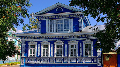
Muzej «Terem russkogo samovara» on the map, Gorodets, Russian Federation
Photo
Where is located Muzej «Terem russkogo samovara»
Muzej «Terem russkogo samovara» — local attraction, which is located at Naberezhnaya Revolyutsii, 11, Gorodets, Nizhny Novgorod Oblast, 606502 and belongs to the category — museum. Average visitor rating for this place — 4.8 (according to 337 ratings, information from open sources and relevant for 2022).
Exact location — Muzej «Terem russkogo samovara», marked on the map with a red marker.
You can get directions to Muzej «Terem russkogo samovara» on the map from your location.
What else is interesting in Gorodets? You can see all the sights if you go to the city page.
Coordinates
Muzej «Terem russkogo samovara», Russian Federation coordinates in decimal format: latitude — 56.642747215387146, longitude — 43.465110898490266. When converted to degrees, minutes, seconds Muzej «Terem russkogo samovara» has the following coordinates: 56°38′33.89 north latitude and 43°27′54.4 east longitude.
Nearby cities
The largest cities that are located nearby:
- Dzerzhinsk — 46 km
- Kovrov — 135 km
- Arzamas — 140 km
- Murom — 150 km
- Kostroma — 194 km
- Vladimir — 197 km
- Cheboksary — 238 km
- Yaroslavl — 239 km
- Novocheboksarsk — 256 km
- Yoshkar-Ola — 267 km
- Saransk — 294 km
- Orekhovo-Zuyevo — 296 km
- Rybinsk — 313 km
- Noginsk — 323 km
- Zelenodolsk — 325 km
- Elektrostal — 326 km
- Ryazan — 330 km
- Kolomna — 344 km
- Vologda — 349 km
Distance to the capital
Distance to the capital (Moscow) is about — 375 km.