
 Mikhaylovka
Dyrestuy
Mikhaylovka
Mayskiy
Novobessergenevka
Tersky District
Lesnoy
Tertezh
Kuz'minskiye Otverzhki
Mikhaylovka
Dyrestuy
Mikhaylovka
Mayskiy
Novobessergenevka
Tersky District
Lesnoy
Tertezh
Kuz'minskiye Otverzhki
Ioanno-Bogoslovskiy Khram on the map, Kolomna, Russian Federation
Photo
Where is located Ioanno-Bogoslovskiy Khram
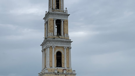
Ioanno-Bogoslovskiy Khram — local attraction, which is located at Двух Революций пл, 1, Kolomna, Moscow Oblast, 140400 and belongs to the category — church. Average visitor rating for this place — 4.8 (according to 69 ratings, information from open sources and relevant for 2022).
Exact location — Ioanno-Bogoslovskiy Khram, marked on the map with a red marker.
You can get directions to Ioanno-Bogoslovskiy Khram on the map from your location.
What else is interesting in Kolomna? You can see all the sights if you go to the city page.
Coordinates
Ioanno-Bogoslovskiy Khram, Russian Federation coordinates in decimal format: latitude — 55.10196492734325, longitude — 38.755337598430245. When converted to degrees, minutes, seconds Ioanno-Bogoslovskiy Khram has the following coordinates: 55°6′7.07 north latitude and 38°45′19.22 east longitude.
Nearby cities
The largest cities that are located nearby:
- Elektrostal — 79 km
- Orekhovo-Zuyevo — 79 km
- Ryazan — 81 km
- Lyubertsy — 85 km
- Podolsk — 85 km
- Izmaylovo — 88 km
- Serpukhov — 88 km
- Noginsk — 89 km
- Balashikha — 94 km
- Odintsovo — 113 km
- Pushkino — 116 km
- Khimki — 121 km
- Tula — 123 km
- Novomoskovsk — 124 km
- Obninsk — 137 km
- Zelenograd — 140 km
- Vladimir — 154 km
- Kaluga — 170 km
- Murom — 211 km
Distance to the capital
Distance to the capital (Moscow) is about — 102 km.