
 Mikhaylovka
Dyrestuy
Mikhaylovka
Mayskiy
Novobessergenevka
Tersky District
Lesnoy
Tertezh
Kuz'minskiye Otverzhki
Mikhaylovka
Dyrestuy
Mikhaylovka
Mayskiy
Novobessergenevka
Tersky District
Lesnoy
Tertezh
Kuz'minskiye Otverzhki
Zvenigorodskiy Istoriko-Arkhitekturnyy I Khudozhestvennyy Muzey on the map, Zvenigorod, Russian Federation
Photo
Where is located Zvenigorodskiy Istoriko-Arkhitekturnyy I Khudozhestvennyy Muzey
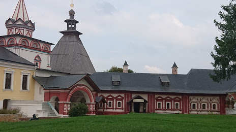
Zvenigorodskiy Istoriko-Arkhitekturnyy I Khudozhestvennyy Muzey — local attraction, which is located at Царицыны палаты Саввино-Сторожевского монастыря, Zvenigorod, Moscow Oblast, 143180 and belongs to the category — museum. Average visitor rating for this place — 4.7 (according to 118 ratings, information from open sources and relevant for 2022).
Exact location — Zvenigorodskiy Istoriko-Arkhitekturnyy I Khudozhestvennyy Muzey, marked on the map with a red marker.
You can get directions to Zvenigorodskiy Istoriko-Arkhitekturnyy I Khudozhestvennyy Muzey on the map from your location.
What else is interesting in Zvenigorod? You can see all the sights if you go to the city page.
Coordinates
Zvenigorodskiy Istoriko-Arkhitekturnyy I Khudozhestvennyy Muzey, Russian Federation coordinates in decimal format: latitude — 55.7283541582084, longitude — 36.81672059845445. When converted to degrees, minutes, seconds Zvenigorodskiy Istoriko-Arkhitekturnyy I Khudozhestvennyy Muzey has the following coordinates: 55°43′42.07 north latitude and 36°49′0.19 east longitude.
Nearby cities
The largest cities that are located nearby:
- Odintsovo — 27 km
- Zelenograd — 36 km
- Khimki — 41 km
- Izmaylovo — 52 km
- Podolsk — 55 km
- Lyubertsy — 65 km
- Pushkino — 67 km
- Balashikha — 70 km
- Obninsk — 70 km
- Serpukhov — 97 km
- Elektrostal — 100 km
- Noginsk — 101 km
- Orekhovo-Zuyevo — 131 km
- Kaluga — 135 km
- Tver — 137 km
- Kolomna — 140 km
- Tula — 176 km
- Novomoskovsk — 212 km
- Ryazan — 221 km
Distance to the capital
Distance to the capital (Moscow) is about — 50 km.