
 Mikhaylovka
Dyrestuy
Mikhaylovka
Mayskiy
Novobessergenevka
Tersky District
Lesnoy
Tertezh
Kuz'minskiye Otverzhki
Mikhaylovka
Dyrestuy
Mikhaylovka
Mayskiy
Novobessergenevka
Tersky District
Lesnoy
Tertezh
Kuz'minskiye Otverzhki
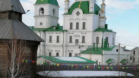
The museum complex Yalutorovsk burg on the map, Yalutorovsk, Russian Federation
Photo
Where is located The museum complex Yalutorovsk burg
The museum complex Yalutorovsk burg — local attraction, which is located at Ulitsa Lenina, 6, Yalutorovsk, Tyumen Oblast, 627010 and belongs to the category — museum. Average visitor rating for this place — 4.7 (according to 509 ratings, information from open sources and relevant for 2022).
Exact location — The museum complex Yalutorovsk burg, marked on the map with a red marker.
You can get directions to The museum complex Yalutorovsk burg on the map from your location.
What else is interesting in Yalutorovsk? You can see all the sights if you go to the city page.
Coordinates
The museum complex Yalutorovsk burg, Russian Federation coordinates in decimal format: latitude — 56.64942179085549, longitude — 66.3204613984905. When converted to degrees, minutes, seconds The museum complex Yalutorovsk burg has the following coordinates: 56°38′57.92 north latitude and 66°19′13.66 east longitude.
Nearby cities
The largest cities that are located nearby:
- Tyumen — 73 km
- Kurgan — 143 km
- Yekaterinburg — 344 km
- Chelyabinsk — 347 km
- Pervouralsk — 383 km
- Kostanay
 (Kazakhstan) — 418 km
 - Kokshetau (Kazakhstan) — 424 km
- Miass — 433 km
- Zlatoust — 449 km
- Omsk — 486 km
- Nefteyugansk — 596 km
- Magnitogorsk — 599 km
- Perm — 603 km
- Berezniki — 616 km
- Solikamsk — 627 km
- Surgut — 635 km
- Ufa — 691 km
- Nizhnevartovsk — 727 km
- Neftekamsk — 742 km
Distance to the capital
Distance to the capital (Moscow) is about — 1766 km.