
 Mikhaylovka
Dyrestuy
Mikhaylovka
Mayskiy
Novobessergenevka
Tersky District
Lesnoy
Tertezh
Kuz'minskiye Otverzhki
Mikhaylovka
Dyrestuy
Mikhaylovka
Mayskiy
Novobessergenevka
Tersky District
Lesnoy
Tertezh
Kuz'minskiye Otverzhki
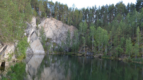
Tal'kov Kamen' on the map, Sysert, Russian Federation
Photo
Where is located Tal'kov Kamen'
Tal'kov Kamen' — local attraction, which is located at 269 m and belongs to the category — -. Average visitor rating for this place — 4.8 (according to 211 ratings, information from open sources and relevant for 2022).
Exact location — Tal'kov Kamen', marked on the map with a red marker.
You can get directions to Tal'kov Kamen' on the map from your location.
What else is interesting in Sysert? You can see all the sights if you go to the city page.
Coordinates
Tal'kov Kamen', Russian Federation coordinates in decimal format: latitude — 56.49285726579302, longitude — 60.72790504848436. When converted to degrees, minutes, seconds Tal'kov Kamen' has the following coordinates: 56°29′34.29 north latitude and 60°43′40.46 east longitude.
Nearby cities
The largest cities that are located nearby:
- Yekaterinburg — 40 km
- Pervouralsk — 70 km
- Chelyabinsk — 153 km
- Zlatoust — 164 km
- Miass — 172 km
- Tyumen — 292 km
- Kurgan — 306 km
- Perm — 311 km
- Magnitogorsk — 362 km
- Ufa — 365 km
- Berezniki — 394 km
- Neftekamsk — 405 km
- Kostanay
 (Kazakhstan) — 408 km
 - Solikamsk — 415 km
- Sarapul — 429 km
- Sterlitamak — 450 km
- Izhevsk — 463 km
- Salavat — 473 km
- Glazov — 509 km
Distance to the capital
Distance to the capital (Moscow) is about — 1428 km.