
 Mikhaylovka
Dyrestuy
Mikhaylovka
Mayskiy
Novobessergenevka
Tersky District
Lesnoy
Tertezh
Kuz'minskiye Otverzhki
Mikhaylovka
Dyrestuy
Mikhaylovka
Mayskiy
Novobessergenevka
Tersky District
Lesnoy
Tertezh
Kuz'minskiye Otverzhki
Ozero Koltushskoye on the map, Vsevolozhsk, Russian Federation
Photo
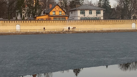
Where is located Ozero Koltushskoye
Ozero Koltushskoye — local attraction, which is located at no data and belongs to the category — -. Average visitor rating for this place — 4.0 (according to 29 ratings, information from open sources and relevant for 2022).
Exact location — Ozero Koltushskoye, marked on the map with a red marker.
You can get directions to Ozero Koltushskoye on the map from your location.
What else is interesting in Vsevolozhsk? You can see all the sights if you go to the city page.
Coordinates
Ozero Koltushskoye, Russian Federation coordinates in decimal format: latitude — 59.935205949790785, longitude — 30.657191444552264. When converted to degrees, minutes, seconds Ozero Koltushskoye has the following coordinates: 59°56′6.74 north latitude and 30°39′25.89 east longitude.
Nearby cities
The largest cities that are located nearby:
- Saint Petersburg — 21 km
- Kolpino — 33 km
- Petrozavodsk — 272 km
- Pskov — 281 km
- Tartu
 (Estonia) — 293 km
 - Vantaa
 (Finland) — 310 km
 - Helsinki (Finland) — 315 km
- Espoo (Finland) — 331 km
- Tallinn (Estonia) — 339 km
- Tampere (Finland) — 399 km
- Velikiye Luki — 408 km
- Cherepovets — 423 km
- Turku (Finland) — 460 km
- Tver — 473 km
- Navapolatsk
 (Belarus) — 517 km
 - Rīga
 (Latvia) — 522 km
 - Rybinsk — 526 km
- Daugavpils (Latvia) — 526 km
- Vologda — 530 km
Distance to the capital
Distance to the capital (Moscow) is about — 621 km.