
 Mikhaylovka
Dyrestuy
Mikhaylovka
Mayskiy
Novobessergenevka
Tersky District
Lesnoy
Tertezh
Kuz'minskiye Otverzhki
Mikhaylovka
Dyrestuy
Mikhaylovka
Mayskiy
Novobessergenevka
Tersky District
Lesnoy
Tertezh
Kuz'minskiye Otverzhki
Krylo Ikara on the map, Akhtubinsk, Russian Federation
Photo
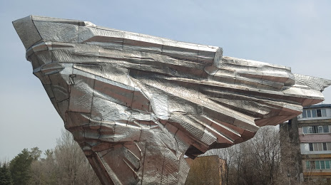
Where is located Krylo Ikara
Krylo Ikara — local attraction, which is located at Akhtubinsk, Astrakhan Oblast, 416506 and belongs to the category — park. Average visitor rating for this place — 4.8 (according to 637 ratings, information from open sources and relevant for 2022).
Exact location — Krylo Ikara, marked on the map with a red marker.
You can get directions to Krylo Ikara on the map from your location.
What else is interesting in Akhtubinsk? You can see all the sights if you go to the city page.
Coordinates
Krylo Ikara, Russian Federation coordinates in decimal format: latitude — 48.280340567053834, longitude — 46.160873798179026. When converted to degrees, minutes, seconds Krylo Ikara has the following coordinates: 48°16′49.23 north latitude and 46°9′39.15 east longitude.
Nearby cities
The largest cities that are located nearby:
- Volzhskiy — 117 km
- Volgograd — 127 km
- Kamyshin — 204 km
- Astrakhan — 259 km
- Elista — 262 km
- Volgodonsk — 309 km
- Engels — 354 km
- Saratov — 358 km
- Balakovo — 427 km
- Shakhty — 445 km
- Atyrau
 (Kazakhstan) — 455 km
 - Novocherkassk — 464 km
- Stavropol — 485 km
- Bataysk — 499 km
- Luhansk
 — 501 km
 - Nevinnomyssk — 524 km
- Pyatigorsk — 531 km
- Alchevs'k — 539 km
- Penza — 547 km
Distance to the capital
Distance to the capital (Moscow) is about — 1015 km.