
 Mikhaylovka
Dyrestuy
Mikhaylovka
Mayskiy
Novobessergenevka
Tersky District
Lesnoy
Tertezh
Kuz'minskiye Otverzhki
Mikhaylovka
Dyrestuy
Mikhaylovka
Mayskiy
Novobessergenevka
Tersky District
Lesnoy
Tertezh
Kuz'minskiye Otverzhki
Ragnit Castle on the map, Neman, Russian Federation
Photo
Where is located Ragnit Castle
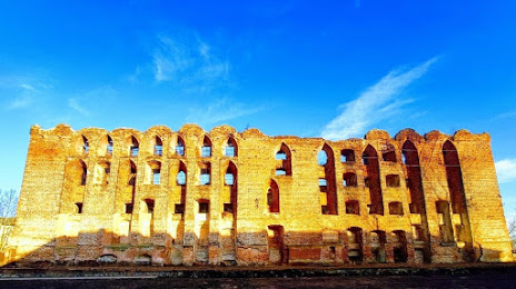
Ragnit Castle — local attraction, which is located at Ulitsa Pobedy, 47, Neman, Kaliningrad Oblast, 238710 and belongs to the category — historical landmark. Average visitor rating for this place — 4.4 (according to 875 ratings, information from open sources and relevant for 2022).
Exact location — Ragnit Castle, marked on the map with a red marker.
You can get directions to Ragnit Castle on the map from your location.
What else is interesting in Neman? You can see all the sights if you go to the city page.
Coordinates
Ragnit Castle, Russian Federation coordinates in decimal format: latitude — 55.039166353889165, longitude — 22.029418498427873. When converted to degrees, minutes, seconds Ragnit Castle has the following coordinates: 55°2′21 north latitude and 22°1′45.91 east longitude.
Nearby cities
The largest cities that are located nearby:
- Klaipėda
 (Lithuania) — 92 km
 - Kaliningrad — 103 km
- Kaunas (Lithuania) — 120 km
- Šiauliai (Lithuania) — 127 km
- Panevėžys (Lithuania) — 164 km
- Olsztyn
 (Poland) — 172 km
 - Elblag (Poland) — 196 km
- Vilnius (Lithuania) — 211 km
- Bialystok (Poland) — 223 km
- Gdańsk (Poland) — 231 km
- Gdynia (Poland) — 232 km
- Rīga
 (Latvia) — 246 km
 - Daugavpils (Latvia) — 294 km
- Plock (Poland) — 316 km
- Warsaw (Poland) — 318 km
- Torun (Poland) — 319 km
- Maladzyechna
 (Belarus) — 321 km
 - Wloclawek (Poland) — 330 km
- Baranovichi (Belarus) — 338 km
Distance to the capital
Distance to the capital (Moscow) is about — 986 km.