
 Mikhaylovka
Dyrestuy
Mikhaylovka
Mayskiy
Novobessergenevka
Tersky District
Lesnoy
Tertezh
Kuz'minskiye Otverzhki
Mikhaylovka
Dyrestuy
Mikhaylovka
Mayskiy
Novobessergenevka
Tersky District
Lesnoy
Tertezh
Kuz'minskiye Otverzhki
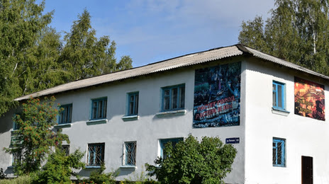
Istoricheskiy Muzey Tayginskogo Gorodskogo Okruga on the map, Tayga, Russian Federation
Photo
Where is located Istoricheskiy Muzey Tayginskogo Gorodskogo Okruga
Istoricheskiy Muzey Tayginskogo Gorodskogo Okruga — local attraction, which is located at Pochtovaya Ulitsa, 99/2, Tayga, Kemerovo Oblast, 652400 and belongs to the category — history museum. Average visitor rating for this place — 4.9 (according to 9 ratings, information from open sources and relevant for 2022).
Exact location — Istoricheskiy Muzey Tayginskogo Gorodskogo Okruga, marked on the map with a red marker.
You can get directions to Istoricheskiy Muzey Tayginskogo Gorodskogo Okruga on the map from your location.
What else is interesting in Tayga? You can see all the sights if you go to the city page.
Coordinates
Istoricheskiy Muzey Tayginskogo Gorodskogo Okruga, Russian Federation coordinates in decimal format: latitude — 56.05879555431274, longitude — 85.6224301984674. When converted to degrees, minutes, seconds Istoricheskiy Muzey Tayginskogo Gorodskogo Okruga has the following coordinates: 56°3′31.66 north latitude and 85°37′20.75 east longitude.
Nearby cities
The largest cities that are located nearby:
- Tomsk — 61 km
- Seversk — 75 km
- Leninsk-Kuznetskiy — 160 km
- Novosibirsk — 206 km
- Prokopyevsk — 252 km
- Novokuznetsk — 273 km
- Achinsk — 301 km
- Mezhdurechensk — 308 km
- Barnaul — 324 km
- Biysk — 392 km
- Krasnoyarsk — 450 km
- Abakan — 460 km
- Rubtsovsk — 588 km
- Kansk — 621 km
- Oskemen
 (Kazakhstan) — 707 km
 - Pavlodar (Kazakhstan) — 719 km
- Nizhnevartovsk — 727 km
- Semey (Kazakhstan) — 729 km
- Kyzyl — 773 km
Distance to the capital
Distance to the capital (Moscow) is about — 2932 km.