
 Mikhaylovka
Dyrestuy
Mikhaylovka
Mayskiy
Novobessergenevka
Tersky District
Lesnoy
Tertezh
Kuz'minskiye Otverzhki
Mikhaylovka
Dyrestuy
Mikhaylovka
Mayskiy
Novobessergenevka
Tersky District
Lesnoy
Tertezh
Kuz'minskiye Otverzhki
Chelter-Marmara on the map, Sevastopol, Sevastopol' city
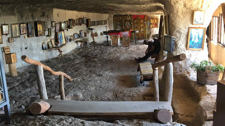
Photo
Where is located Chelter-Marmara
Chelter-Marmara — local attraction, which is located at Unnamed Road and belongs to the category — monastery. Average visitor rating for this place — 4.9 (according to 9 ratings, information from open sources and relevant for 2022).
Exact location — Chelter-Marmara, marked on the map with a red marker.
You can get directions to Chelter-Marmara on the map from your location.
What else is interesting in Sevastopol? You can see all the sights if you go to the city page.
Coordinates
Chelter-Marmara coordinates in decimal format: latitude — 44.59481033001424, longitude — 33.75225042728098. When converted to degrees, minutes, seconds Chelter-Marmara has the following coordinates: 44°35′41.32 north latitude and 33°45′8.1 east longitude.
Nearby cities
The largest cities that are located nearby:
- Simferopol — 58 km
- Yevpatoriya — 65 km
- Kherson
 — 234 km
 - Kerch — 243 km
- Melitopol' — 282 km
- Odessa
 (Ukraine) — 297 km
 - Novorossiysk — 332 km
- Nikopol' (Ukraine) — 333 km
- Berdyans'k — 342 km
- Kryvyi Rih (Ukraine) — 364 km
- Zonguldak
 (Turkey) — 378 km
 - Constanța
 (Romania) — 391 km
 - Bender
 (Moldova) — 392 km
 - Krasnodar — 428 km
- Galați (Romania) — 435 km
- Samsun (Turkey) — 435 km
- Chisinau (Moldova) — 436 km
- Dniprodzerzhyns'k (Ukraine) — 439 km
- Brăila (Romania) — 439 km
Distance to the capital
Distance to the capital (Moscow) is about — 1271 km.