
 Mikhaylovka
Dyrestuy
Mikhaylovka
Mayskiy
Novobessergenevka
Tersky District
Lesnoy
Tertezh
Kuz'minskiye Otverzhki
Mikhaylovka
Dyrestuy
Mikhaylovka
Mayskiy
Novobessergenevka
Tersky District
Lesnoy
Tertezh
Kuz'minskiye Otverzhki
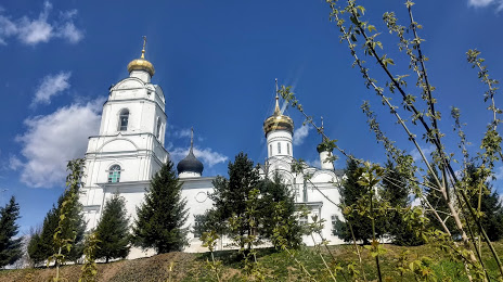
Svyato-Troitskiy Kafedral'nyy Sobor on the map, Vyazma, Russian Federation
Photo
Where is located Svyato-Troitskiy Kafedral'nyy Sobor
Svyato-Troitskiy Kafedral'nyy Sobor — local attraction, which is located at Nagornyy Pereulok, 1, Vyazma, Smolensk Oblast, 215110 and belongs to the category — church. Average visitor rating for this place — 4.8 (according to 149 ratings, information from open sources and relevant for 2022).
Exact location — Svyato-Troitskiy Kafedral'nyy Sobor, marked on the map with a red marker.
You can get directions to Svyato-Troitskiy Kafedral'nyy Sobor on the map from your location.
What else is interesting in Vyazma? You can see all the sights if you go to the city page.
Coordinates
Svyato-Troitskiy Kafedral'nyy Sobor, Russian Federation coordinates in decimal format: latitude — 55.212268229004806, longitude — 34.28728499843454. When converted to degrees, minutes, seconds Svyato-Troitskiy Kafedral'nyy Sobor has the following coordinates: 55°12′44.17 north latitude and 34°17′14.23 east longitude.
Nearby cities
The largest cities that are located nearby:
- Obninsk — 147 km
- Kaluga — 147 km
- Smolensk — 149 km
- Odintsovo — 193 km
- Zelenograd — 200 km
- Serpukhov — 202 km
- Podolsk — 206 km
- Tver — 208 km
- Khimki — 210 km
- Izmaylovo — 214 km
- Bryansk — 214 km
- Lyubertsy — 232 km
- Pushkino — 237 km
- Balashikha — 239 km
- Tula — 242 km
- Velikiye Luki — 262 km
- Elektrostal — 268 km
- Noginsk — 270 km
- Kolomna — 284 km
Distance to the capital
Distance to the capital (Moscow) is about — 218 km.