
 Mikhaylovka
Dyrestuy
Mikhaylovka
Mayskiy
Novobessergenevka
Tersky District
Lesnoy
Tertezh
Kuz'minskiye Otverzhki
Mikhaylovka
Dyrestuy
Mikhaylovka
Mayskiy
Novobessergenevka
Tersky District
Lesnoy
Tertezh
Kuz'minskiye Otverzhki
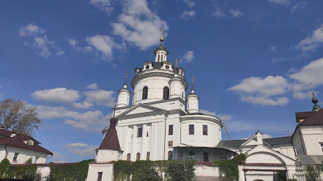
Nikolo-Chernoostrovskiy Monastyr' on the map, Maloyaroslavets, Russian Federation
Photo
Where is located Nikolo-Chernoostrovskiy Monastyr'
Nikolo-Chernoostrovskiy Monastyr' — local attraction, which is located at Ulitsa Kutuzova, д. 23, Maloyaroslavets, Kaluga Oblast, 249096 and belongs to the category — monastery. Average visitor rating for this place — 4.4 (according to 11 ratings, information from open sources and relevant for 2022).
Exact location — Nikolo-Chernoostrovskiy Monastyr', marked on the map with a red marker.
You can get directions to Nikolo-Chernoostrovskiy Monastyr' on the map from your location.
What else is interesting in Maloyaroslavets? You can see all the sights if you go to the city page.
Coordinates
Nikolo-Chernoostrovskiy Monastyr', Russian Federation coordinates in decimal format: latitude — 55.01640683595139, longitude — 36.462342348427. When converted to degrees, minutes, seconds Nikolo-Chernoostrovskiy Monastyr' has the following coordinates: 55°0′59.06 north latitude and 36°27′44.43 east longitude.
Nearby cities
The largest cities that are located nearby:
- Obninsk — 14 km
- Kaluga — 53 km
- Serpukhov — 62 km
- Podolsk — 82 km
- Odintsovo — 87 km
- Izmaylovo — 95 km
- Khimki — 114 km
- Lyubertsy — 116 km
- Tula — 117 km
- Zelenograd — 117 km
- Balashikha — 128 km
- Pushkino — 138 km
- Kolomna — 146 km
- Elektrostal — 150 km
- Noginsk — 156 km
- Novomoskovsk — 163 km
- Orekhovo-Zuyevo — 178 km
- Tver — 206 km
- Ryazan — 213 km
Distance to the capital
Distance to the capital (Moscow) is about — 110 km.