
 Mikhaylovka
Dyrestuy
Mikhaylovka
Mayskiy
Novobessergenevka
Tersky District
Lesnoy
Tertezh
Kuz'minskiye Otverzhki
Mikhaylovka
Dyrestuy
Mikhaylovka
Mayskiy
Novobessergenevka
Tersky District
Lesnoy
Tertezh
Kuz'minskiye Otverzhki
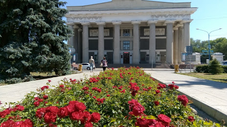
DK VGS on the map, Volzhskiy, Russian Federation
Photo
Where is located DK VGS
DK VGS — local attraction, which is located at пл 404130, Komsomol'skaya Ploshchad', 1, Volzhskiy, Volgograd Oblast, 404130 and belongs to the category — cultural center. Average visitor rating for this place — 4.6 (according to 972 ratings, information from open sources and relevant for 2022).
Exact location — DK VGS, marked on the map with a red marker.
You can get directions to DK VGS on the map from your location.
What else is interesting in Volzhskiy? You can see all the sights if you go to the city page.
Coordinates
DK VGS, Russian Federation coordinates in decimal format: latitude — 48.805418435436856, longitude — 44.73924309819751. When converted to degrees, minutes, seconds DK VGS has the following coordinates: 48°48′19.51 north latitude and 44°44′21.28 east longitude.
Nearby cities
The largest cities that are located nearby:
- Volgograd — 20 km
- Kamyshin — 149 km
- Volgodonsk — 239 km
- Elista — 278 km
- Engels — 313 km
- Saratov — 314 km
- Shakhty — 357 km
- Astrakhan — 371 km
- Novocherkassk — 381 km
- Luhansk
 — 398 km
 - Balakovo — 412 km
- Bataysk — 419 km
- Alchevs'k — 437 km
- Stavropol — 468 km
- Taganrog — 471 km
- Tambov — 486 km
- Penza — 486 km
- Voronezh — 495 km
- Horlivka — 497 km
Distance to the capital
Distance to the capital (Moscow) is about — 911 km.