
 Mikhaylovka
Dyrestuy
Mikhaylovka
Mayskiy
Novobessergenevka
Tersky District
Lesnoy
Tertezh
Kuz'minskiye Otverzhki
Mikhaylovka
Dyrestuy
Mikhaylovka
Mayskiy
Novobessergenevka
Tersky District
Lesnoy
Tertezh
Kuz'minskiye Otverzhki
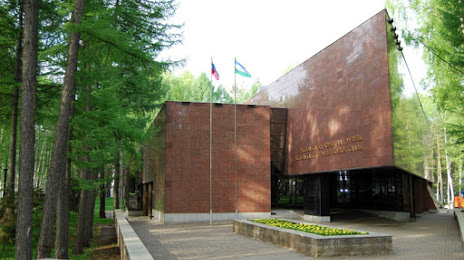
Respublikanskiy Muzey Boyevoy Slavy on the map, Ufa, Russian Federation
Photo
Where is located Respublikanskiy Muzey Boyevoy Slavy
Respublikanskiy Muzey Boyevoy Slavy — local attraction, which is located at Ulitsa Komarova, 7, Ufa, Republic of Bashkortostan, 450044 and belongs to the category — museum. Average visitor rating for this place — 4.8 (according to 271 rating, information from open sources and relevant for 2022).
Exact location — Respublikanskiy Muzey Boyevoy Slavy, marked on the map with a red marker.
You can get directions to Respublikanskiy Muzey Boyevoy Slavy on the map from your location.
What else is interesting in Ufa? You can see all the sights if you go to the city page.
Coordinates
Respublikanskiy Muzey Boyevoy Slavy, Russian Federation coordinates in decimal format: latitude — 54.82202433589071, longitude — 56.05713739841952. When converted to degrees, minutes, seconds Respublikanskiy Muzey Boyevoy Slavy has the following coordinates: 54°49′19.29 north latitude and 56°3′25.69 east longitude.
Nearby cities
The largest cities that are located nearby:
- Sterlitamak — 122 km
- Salavat — 152 km
- Neftekamsk — 183 km
- Sarapul — 233 km
- Almetyevsk — 233 km
- Zlatoust — 238 km
- Magnitogorsk — 248 km
- Miass — 263 km
- Nizhnekamsk — 278 km
- Izhevsk — 287 km
- Orenburg — 334 km
- Pervouralsk — 340 km
- Chelyabinsk — 348 km
- Perm — 361 km
- Yekaterinburg — 364 km
- Dimitrovgrad — 418 km
- Samara — 422 km
- Glazov — 422 km
- Novotroitsk — 423 km
Distance to the capital
Distance to the capital (Moscow) is about — 1169 km.