
 Mikhaylovka
Dyrestuy
Mikhaylovka
Mayskiy
Novobessergenevka
Tersky District
Lesnoy
Tertezh
Kuz'minskiye Otverzhki
Mikhaylovka
Dyrestuy
Mikhaylovka
Mayskiy
Novobessergenevka
Tersky District
Lesnoy
Tertezh
Kuz'minskiye Otverzhki
Eläintarha Tšudo-ostrov 'Ihmesaari' on the map, Medvedevo, Russian Federation
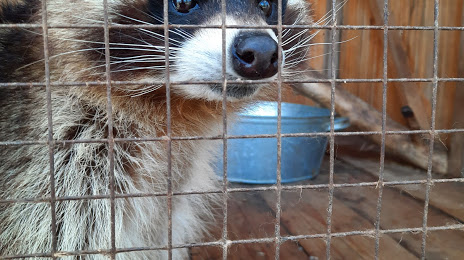
Photo
Where is located Eläintarha Tšudo-ostrov 'Ihmesaari'
Eläintarha Tšudo-ostrov 'Ihmesaari' — local attraction, which is located at Ulitsa Mosolova, 18, Medvedevo, Mari El Republic, 425200 and belongs to the category — zoo. Average visitor rating for this place — 4.6 (according to 926 ratings, information from open sources and relevant for 2022).
Exact location — Eläintarha Tšudo-ostrov 'Ihmesaari', marked on the map with a red marker.
You can get directions to Eläintarha Tšudo-ostrov 'Ihmesaari' on the map from your location.
What else is interesting in Medvedevo? You can see all the sights if you go to the city page.
Coordinates
Eläintarha Tšudo-ostrov 'Ihmesaari', Russian Federation coordinates in decimal format: latitude — 56.63180535559846, longitude — 47.80777779848979. When converted to degrees, minutes, seconds Eläintarha Tšudo-ostrov 'Ihmesaari' has the following coordinates: 56°37′54.5 north latitude and 47°48′28 east longitude.
Nearby cities
The largest cities that are located nearby:
- Yoshkar-Ola — 3 km
- Novocheboksarsk — 62 km
- Cheboksary — 64 km
- Zelenodolsk — 97 km
- Kazan — 124 km
- Kirov — 243 km
- Ulyanovsk — 259 km
- Dzerzhinsk — 272 km
- Nizhnekamsk — 273 km
- Arzamas — 286 km
- Dimitrovgrad — 289 km
- Saransk — 320 km
- Izhevsk — 325 km
- Glazov — 328 km
- Almetyevsk — 345 km
- Tolyatti — 361 km
- Sarapul — 366 km
- Murom — 380 km
- Syzran — 386 km
Distance to the capital
Distance to the capital (Moscow) is about — 638 km.