
 Mikhaylovka
Dyrestuy
Mikhaylovka
Mayskiy
Novobessergenevka
Tersky District
Lesnoy
Tertezh
Kuz'minskiye Otverzhki
Mikhaylovka
Dyrestuy
Mikhaylovka
Mayskiy
Novobessergenevka
Tersky District
Lesnoy
Tertezh
Kuz'minskiye Otverzhki
Plyazh Ostrovok on the map, Razumnoye, Russian Federation
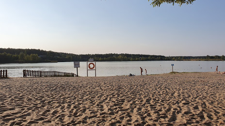
Photo
Where is located Plyazh Ostrovok
Plyazh Ostrovok — local attraction, which is located at no data and belongs to the category — -. Average visitor rating for this place — 4.6 (according to 1383 ratings, information from open sources and relevant for 2022).
Exact location — Plyazh Ostrovok, marked on the map with a red marker.
You can get directions to Plyazh Ostrovok on the map from your location.
What else is interesting in Razumnoye? You can see all the sights if you go to the city page.
Coordinates
Plyazh Ostrovok, Russian Federation coordinates in decimal format: latitude — 50.5000328365877, longitude — 36.67547489045155. When converted to degrees, minutes, seconds Plyazh Ostrovok has the following coordinates: 50°30′0.12 north latitude and 36°40′31.71 east longitude.
Nearby cities
The largest cities that are located nearby:
- Belgorod — 10 km
- Kursk — 135 km
- Sumy
 (Ukraine) — 138 km
 - Poltava (Ukraine) — 186 km
- Voronezh — 214 km
- Pavlohrad (Ukraine) — 231 km
- Yelets — 261 km
- Horlivka
 — 265 km
 - Dniprodzerzhyns'k (Ukraine) — 269 km
- Alchevs'k — 275 km
- Kremenchuk (Ukraine) — 288 km
- Luhansk — 289 km
- Donetsk — 290 km
- Lipetsk — 302 km
- Bryansk — 337 km
- Cherkasy (Ukraine) — 354 km
- Nikopol' (Ukraine) — 370 km
- Kryvyi Rih (Ukraine) — 379 km
- Chernihiv (Ukraine) — 387 km
Distance to the capital
Distance to the capital (Moscow) is about — 588 km.