
 Mikhaylovka
Dyrestuy
Mikhaylovka
Mayskiy
Novobessergenevka
Tersky District
Lesnoy
Tertezh
Kuz'minskiye Otverzhki
Mikhaylovka
Dyrestuy
Mikhaylovka
Mayskiy
Novobessergenevka
Tersky District
Lesnoy
Tertezh
Kuz'minskiye Otverzhki
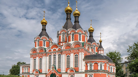
Preobrazhenskiy Sobor on the map, Kimry, Russian Federation
Photo
Where is located Preobrazhenskiy Sobor
Preobrazhenskiy Sobor — local attraction, which is located at Ulitsa Uritskogo, 65, Kimry, Tver Oblast, 171507 and belongs to the category — russian orthodox church. Average visitor rating for this place — 4.7 (according to 107 ratings, information from open sources and relevant for 2022).
Exact location — Preobrazhenskiy Sobor, marked on the map with a red marker.
You can get directions to Preobrazhenskiy Sobor on the map from your location.
What else is interesting in Kimry? You can see all the sights if you go to the city page.
Coordinates
Preobrazhenskiy Sobor, Russian Federation coordinates in decimal format: latitude — 56.87759215111549, longitude — 37.34455179849946. When converted to degrees, minutes, seconds Preobrazhenskiy Sobor has the following coordinates: 56°52′39.33 north latitude and 37°20′40.39 east longitude.
Nearby cities
The largest cities that are located nearby:
- Tver — 87 km
- Zelenograd — 96 km
- Pushkino — 100 km
- Khimki — 107 km
- Balashikha — 121 km
- Noginsk — 129 km
- Odintsovo — 132 km
- Lyubertsy — 134 km
- Elektrostal — 138 km
- Izmaylovo — 144 km
- Orekhovo-Zuyevo — 154 km
- Rybinsk — 157 km
- Podolsk — 158 km
- Yaroslavl — 172 km
- Obninsk — 199 km
- Vladimir — 204 km
- Kolomna — 215 km
- Serpukhov — 215 km
- Kostroma — 233 km
Distance to the capital
Distance to the capital (Moscow) is about — 126 km.