
 Mikhaylovka
Dyrestuy
Mikhaylovka
Mayskiy
Novobessergenevka
Tersky District
Lesnoy
Tertezh
Kuz'minskiye Otverzhki
Mikhaylovka
Dyrestuy
Mikhaylovka
Mayskiy
Novobessergenevka
Tersky District
Lesnoy
Tertezh
Kuz'minskiye Otverzhki
Isaakiyevskoye Ozero on the map, Orekhovo-Zuyevo, Russian Federation
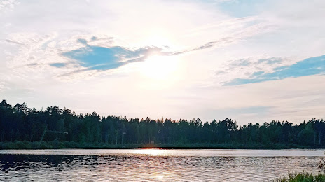
Photo
Where is located Isaakiyevskoye Ozero
Isaakiyevskoye Ozero — local attraction, which is located at no data and belongs to the category — -. Average visitor rating for this place — 4.6 (according to 84 ratings, information from open sources and relevant for 2022).
Exact location — Isaakiyevskoye Ozero, marked on the map with a red marker.
You can get directions to Isaakiyevskoye Ozero on the map from your location.
What else is interesting in Orekhovo-Zuyevo? You can see all the sights if you go to the city page.
Coordinates
Isaakiyevskoye Ozero, Russian Federation coordinates in decimal format: latitude — 55.81315881103173, longitude — 38.938636893896046. When converted to degrees, minutes, seconds Isaakiyevskoye Ozero has the following coordinates: 55°48′47.37 north latitude and 38°56′19.09 east longitude.
Nearby cities
The largest cities that are located nearby:
- Elektrostal — 31 km
- Noginsk — 32 km
- Balashikha — 62 km
- Lyubertsy — 68 km
- Pushkino — 73 km
- Kolomna — 79 km
- Izmaylovo — 87 km
- Khimki — 95 km
- Vladimir — 97 km
- Podolsk — 98 km
- Odintsovo — 107 km
- Zelenograd — 112 km
- Serpukhov — 138 km
- Ryazan — 140 km
- Kovrov — 158 km
- Obninsk — 168 km
- Murom — 193 km
- Tula — 197 km
- Novomoskovsk — 203 km
Distance to the capital
Distance to the capital (Moscow) is about — 83 km.