
 Mikhaylovka
Dyrestuy
Mikhaylovka
Mayskiy
Novobessergenevka
Tersky District
Lesnoy
Tertezh
Kuz'minskiye Otverzhki
Mikhaylovka
Dyrestuy
Mikhaylovka
Mayskiy
Novobessergenevka
Tersky District
Lesnoy
Tertezh
Kuz'minskiye Otverzhki
Voskresenskiy Sobor on the map, Tutayev, Russian Federation
Photo
Where is located Voskresenskiy Sobor
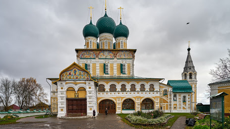
Voskresenskiy Sobor — local attraction, which is located at Ulitsa Sobornaya, 13а, Tutayev, Yaroslavl Oblast, 152300 and belongs to the category — orthodox church. Average visitor rating for this place — 4.9 (according to 1044 ratings, information from open sources and relevant for 2022).
Exact location — Voskresenskiy Sobor, marked on the map with a red marker.
You can get directions to Voskresenskiy Sobor on the map from your location.
What else is interesting in Tutayev? You can see all the sights if you go to the city page.
Coordinates
Voskresenskiy Sobor, Russian Federation coordinates in decimal format: latitude — 57.87423595772205, longitude — 39.52704149853884. When converted to degrees, minutes, seconds Voskresenskiy Sobor has the following coordinates: 57°52′27.25 north latitude and 39°31′37.35 east longitude.
Nearby cities
The largest cities that are located nearby:
- Yaroslavl — 35 km
- Rybinsk — 46 km
- Kostroma — 83 km
- Vologda — 149 km
- Cherepovets — 167 km
- Vladimir — 200 km
- Kovrov — 200 km
- Noginsk — 232 km
- Orekhovo-Zuyevo — 233 km
- Pushkino — 234 km
- Elektrostal — 242 km
- Tver — 247 km
- Balashikha — 249 km
- Zelenograd — 254 km
- Khimki — 256 km
- Lyubertsy — 264 km
- Izmaylovo — 283 km
- Odintsovo — 283 km
- Podolsk — 299 km
Distance to the capital
Distance to the capital (Moscow) is about — 263 km.