
 Mikhaylovka
Dyrestuy
Mikhaylovka
Mayskiy
Novobessergenevka
Tersky District
Lesnoy
Tertezh
Kuz'minskiye Otverzhki
Mikhaylovka
Dyrestuy
Mikhaylovka
Mayskiy
Novobessergenevka
Tersky District
Lesnoy
Tertezh
Kuz'minskiye Otverzhki
Nikolo-Bogoyavlenskiy Morskoy Sobor on the map, Shushary, Russian Federation
Photo
Where is located Nikolo-Bogoyavlenskiy Morskoy Sobor
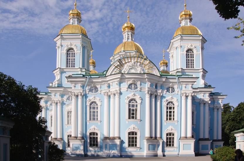
Nikolo-Bogoyavlenskiy Morskoy Sobor — local attraction, which is located at Nikol'skaya Ploshchad', 1/3, St Petersburg, 190068 and belongs to the category — cathedral. Average visitor rating for this place — 4.8 (according to 3514 ratings, information from open sources and relevant for 2022).
Exact location — Nikolo-Bogoyavlenskiy Morskoy Sobor, marked on the map with a red marker.
You can get directions to Nikolo-Bogoyavlenskiy Morskoy Sobor on the map from your location.
What else is interesting in Shushary? You can see all the sights if you go to the city page.
Coordinates
Nikolo-Bogoyavlenskiy Morskoy Sobor, Russian Federation coordinates in decimal format: latitude — 59.922626340681006, longitude — 30.299999998621317. When converted to degrees, minutes, seconds Nikolo-Bogoyavlenskiy Morskoy Sobor has the following coordinates: 59°55′21.45 north latitude and 30°17′60 east longitude.
Nearby cities
The largest cities that are located nearby:
- Kolpino — 14 km
- Saint Petersburg — 15 km
- Pskov — 251 km
- Tartu
 (Estonia) — 265 km
 - Vantaa
 (Finland) — 299 km
 - Petrozavodsk — 300 km
- Helsinki (Finland) — 303 km
- Espoo (Finland) — 318 km
- Tallinn (Estonia) — 320 km
- Velikiye Luki — 383 km
- Tampere (Finland) — 397 km
- Cherepovets — 433 km
- Turku (Finland) — 449 km
- Tver — 467 km
- Navapolatsk
 (Belarus) — 488 km
 - Rīga
 (Latvia) — 494 km
 - Daugavpils (Latvia) — 496 km
- Rybinsk — 531 km
- Vologda — 542 km
Distance to the capital
Distance to the capital (Moscow) is about — 634 km.