
 Mikhaylovka
Dyrestuy
Mikhaylovka
Mayskiy
Novobessergenevka
Tersky District
Lesnoy
Tertezh
Kuz'minskiye Otverzhki
Mikhaylovka
Dyrestuy
Mikhaylovka
Mayskiy
Novobessergenevka
Tersky District
Lesnoy
Tertezh
Kuz'minskiye Otverzhki
Lyantorskiy Khantyyskiy Etnograficheskiy Muzey on the map, Lyantor, Russian Federation
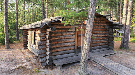
Photo
Where is located Lyantorskiy Khantyyskiy Etnograficheskiy Muzey
Lyantorskiy Khantyyskiy Etnograficheskiy Muzey — local attraction, which is located at Estonskiy Poselok, 50, Lyantor, Ханты-Мансийский Автономный округ - Югра АО, 628449 and belongs to the category — museum. Average visitor rating for this place — 4.7 (according to 78 ratings, information from open sources and relevant for 2022).
Exact location — Lyantorskiy Khantyyskiy Etnograficheskiy Muzey, marked on the map with a red marker.
You can get directions to Lyantorskiy Khantyyskiy Etnograficheskiy Muzey on the map from your location.
What else is interesting in Lyantor? You can see all the sights if you go to the city page.
Coordinates
Lyantorskiy Khantyyskiy Etnograficheskiy Muzey, Russian Federation coordinates in decimal format: latitude — 61.63123087985698, longitude — 72.16027779869137. When converted to degrees, minutes, seconds Lyantorskiy Khantyyskiy Etnograficheskiy Muzey has the following coordinates: 61°37′52.43 north latitude and 72°9′37 east longitude.
Nearby cities
The largest cities that are located nearby:
- Nefteyugansk — 62 km
- Surgut — 79 km
- Nizhnevartovsk — 247 km
- Tyumen — 634 km
- Omsk — 738 km
- Kurgan — 803 km
- Yekaterinburg — 877 km
- Solikamsk — 889 km
- Berezniki — 899 km
- Pervouralsk — 902 km
- Ukhta — 934 km
- Kokshetau
 (Kazakhstan) — 938 km
 - Seversk — 951 km
- Tomsk — 966 km
- Chelyabinsk — 984 km
- Novosibirsk — 1001 km
- Perm — 1011 km
- Norilsk — 1058 km
- Miass — 1059 km
Distance to the capital
Distance to the capital (Moscow) is about — 2072 km.