
 Mikhaylovka
Dyrestuy
Mikhaylovka
Mayskiy
Novobessergenevka
Tersky District
Lesnoy
Tertezh
Kuz'minskiye Otverzhki
Mikhaylovka
Dyrestuy
Mikhaylovka
Mayskiy
Novobessergenevka
Tersky District
Lesnoy
Tertezh
Kuz'minskiye Otverzhki
Usadba «Timohovo-Salazkino» on the map, Vidnoye, Russian Federation
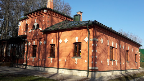
Photo
Where is located Usadba «Timohovo-Salazkino»
Usadba «Timohovo-Salazkino» — local attraction, which is located at Shkol'naya Ulitsa, Vidnoye, Moscow Oblast, 142703 and belongs to the category — museum. Average visitor rating for this place — 4.7 (according to 276 ratings, information from open sources and relevant for 2022).
Exact location — Usadba «Timohovo-Salazkino», marked on the map with a red marker.
You can get directions to Usadba «Timohovo-Salazkino» on the map from your location.
What else is interesting in Vidnoye? You can see all the sights if you go to the city page.
Coordinates
Usadba «Timohovo-Salazkino», Russian Federation coordinates in decimal format: latitude — 55.552522596893304, longitude — 37.69188069844767. When converted to degrees, minutes, seconds Usadba «Timohovo-Salazkino» has the following coordinates: 55°33′9.08 north latitude and 37°41′30.77 east longitude.
Nearby cities
The largest cities that are located nearby:
- Izmaylovo — 4 km
- Podolsk — 16 km
- Lyubertsy — 19 km
- Odintsovo — 30 km
- Balashikha — 34 km
- Khimki — 41 km
- Pushkino — 50 km
- Elektrostal — 54 km
- Zelenograd — 59 km
- Noginsk — 60 km
- Serpukhov — 72 km
- Orekhovo-Zuyevo — 83 km
- Kolomna — 84 km
- Obninsk — 85 km
- Kaluga — 143 km
- Tula — 149 km
- Ryazan — 166 km
- Novomoskovsk — 175 km
- Vladimir — 180 km
Distance to the capital
Distance to the capital (Moscow) is about — 23 km.