
 Mikhaylovka
Dyrestuy
Mikhaylovka
Mayskiy
Novobessergenevka
Tersky District
Lesnoy
Tertezh
Kuz'minskiye Otverzhki
Mikhaylovka
Dyrestuy
Mikhaylovka
Mayskiy
Novobessergenevka
Tersky District
Lesnoy
Tertezh
Kuz'minskiye Otverzhki
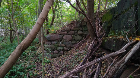
Castle Lohshtedt on the map, Baltiysk, Russian Federation
Photo
Where is located Castle Lohshtedt
Castle Lohshtedt — local attraction, which is located at Baltiysk, Kaliningrad Oblast, 238510 and belongs to the category — tourist attraction. Average visitor rating for this place — 4.1 (according to 95 ratings, information from open sources and relevant for 2022).
Exact location — Castle Lohshtedt, marked on the map with a red marker.
You can get directions to Castle Lohshtedt on the map from your location.
What else is interesting in Baltiysk? You can see all the sights if you go to the city page.
Coordinates
Castle Lohshtedt, Russian Federation coordinates in decimal format: latitude — 54.707295148228, longitude — 19.9514453984151. When converted to degrees, minutes, seconds Castle Lohshtedt has the following coordinates: 54°42′26.26 north latitude and 19°57′5.2 east longitude.
Nearby cities
The largest cities that are located nearby:
- Kaliningrad — 39 km
- Elblag
 (Poland) — 64 km
 - Gdańsk (Poland) — 88 km
- Gdynia (Poland) — 90 km
- Olsztyn (Poland) — 103 km
- Klaipėda
 (Lithuania) — 139 km
 - Torun (Poland) — 201 km
- Bydgoszcz (Poland) — 211 km
- Wloclawek (Poland) — 229 km
- Plock (Poland) — 233 km
- Koszalin (Poland) — 247 km
- Šiauliai (Lithuania) — 254 km
- Kaunas (Lithuania) — 255 km
- Bialystok (Poland) — 273 km
- Warsaw (Poland) — 278 km
- Panevėžys (Lithuania) — 301 km
- Poznań (Poland) — 320 km
- Łódź (Poland) — 321 km
- Kalisz (Poland) — 342 km
Distance to the capital
Distance to the capital (Moscow) is about — 1123 km.