
 Mikhaylovka
Dyrestuy
Mikhaylovka
Mayskiy
Novobessergenevka
Tersky District
Lesnoy
Tertezh
Kuz'minskiye Otverzhki
Mikhaylovka
Dyrestuy
Mikhaylovka
Mayskiy
Novobessergenevka
Tersky District
Lesnoy
Tertezh
Kuz'minskiye Otverzhki
Tekiye Shakh-Ali Khana on the map, Kasimov, Russian Federation
Photo
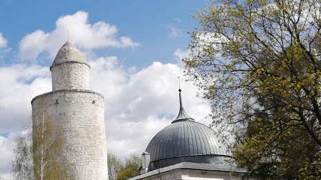
Where is located Tekiye Shakh-Ali Khana
Tekiye Shakh-Ali Khana — local attraction, which is located at Kasimov, Ryazan Oblast, 391302 and belongs to the category — historical landmark. Average visitor rating for this place — 4.4 (according to 16 ratings, information from open sources and relevant for 2022).
Exact location — Tekiye Shakh-Ali Khana, marked on the map with a red marker.
You can get directions to Tekiye Shakh-Ali Khana on the map from your location.
What else is interesting in Kasimov? You can see all the sights if you go to the city page.
Coordinates
Tekiye Shakh-Ali Khana, Russian Federation coordinates in decimal format: latitude — 54.932977536570625, longitude — 41.39661339842386. When converted to degrees, minutes, seconds Tekiye Shakh-Ali Khana has the following coordinates: 54°55′58.72 north latitude and 41°23′47.81 east longitude.
Nearby cities
The largest cities that are located nearby:
- Murom — 79 km
- Ryazan — 114 km
- Vladimir — 145 km
- Kovrov — 157 km
- Arzamas — 160 km
- Kolomna — 167 km
- Orekhovo-Zuyevo — 178 km
- Dzerzhinsk — 190 km
- Elektrostal — 204 km
- Noginsk — 209 km
- Novomoskovsk — 227 km
- Lyubertsy — 233 km
- Balashikha — 234 km
- Izmaylovo — 245 km
- Tambov — 247 km
- Podolsk — 247 km
- Pushkino — 249 km
- Serpukhov — 253 km
- Tula — 258 km
Distance to the capital
Distance to the capital (Moscow) is about — 256 km.