
 Mikhaylovka
Dyrestuy
Mikhaylovka
Mayskiy
Novobessergenevka
Tersky District
Lesnoy
Tertezh
Kuz'minskiye Otverzhki
Mikhaylovka
Dyrestuy
Mikhaylovka
Mayskiy
Novobessergenevka
Tersky District
Lesnoy
Tertezh
Kuz'minskiye Otverzhki
Polotnyanyy Zavod on the map, Tovarkovo, Russian Federation
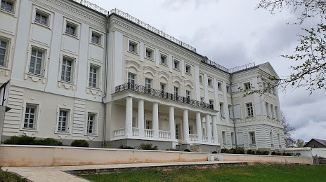
Photo
Where is located Polotnyanyy Zavod
Polotnyanyy Zavod — local attraction, which is located at Trudovaya Ulitsa, 2а, Polotnyanyy Zavod, Kaluga Oblast, 249844 and belongs to the category — historical place museum. Average visitor rating for this place — 4.5 (according to 272 ratings, information from open sources and relevant for 2022).
Exact location — Polotnyanyy Zavod, marked on the map with a red marker.
You can get directions to Polotnyanyy Zavod on the map from your location.
What else is interesting in Tovarkovo? You can see all the sights if you go to the city page.
Coordinates
Polotnyanyy Zavod, Russian Federation coordinates in decimal format: latitude — 54.729174396826274, longitude — 35.979691053993044. When converted to degrees, minutes, seconds Polotnyanyy Zavod has the following coordinates: 54°43′45.03 north latitude and 35°58′46.89 east longitude.
Nearby cities
The largest cities that are located nearby:
- Kaluga — 26 km
- Obninsk — 64 km
- Serpukhov — 98 km
- Tula — 121 km
- Podolsk — 131 km
- Odintsovo — 137 km
- Izmaylovo — 145 km
- Khimki — 164 km
- Zelenograd — 165 km
- Lyubertsy — 166 km
- Novomoskovsk — 170 km
- Balashikha — 178 km
- Kolomna — 185 km
- Bryansk — 186 km
- Pushkino — 188 km
- Elektrostal — 199 km
- Noginsk — 206 km
- Orekhovo-Zuyevo — 226 km
- Tver — 241 km
Distance to the capital
Distance to the capital (Moscow) is about — 154 km.