
 Mikhaylovka
Dyrestuy
Mikhaylovka
Mayskiy
Novobessergenevka
Tersky District
Lesnoy
Tertezh
Kuz'minskiye Otverzhki
Mikhaylovka
Dyrestuy
Mikhaylovka
Mayskiy
Novobessergenevka
Tersky District
Lesnoy
Tertezh
Kuz'minskiye Otverzhki
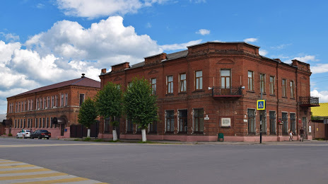
Skopinskiy Krayevedcheskiy Muzey on the map, Skopin, Russian Federation
Photo
Where is located Skopinskiy Krayevedcheskiy Muzey
Skopinskiy Krayevedcheskiy Muzey — local attraction, which is located at Ulitsa Karla Marksa, 95, Skopin, Ryazan Oblast, 391800 and belongs to the category — local history museum. Average visitor rating for this place — 4.6 (according to 121 rating, information from open sources and relevant for 2022).
Exact location — Skopinskiy Krayevedcheskiy Muzey, marked on the map with a red marker.
You can get directions to Skopinskiy Krayevedcheskiy Muzey on the map from your location.
What else is interesting in Skopin? You can see all the sights if you go to the city page.
Coordinates
Skopinskiy Krayevedcheskiy Muzey, Russian Federation coordinates in decimal format: latitude — 53.82349080493256, longitude — 39.54964779838141. When converted to degrees, minutes, seconds Skopinskiy Krayevedcheskiy Muzey has the following coordinates: 53°49′24.57 north latitude and 39°32′58.73 east longitude.
Nearby cities
The largest cities that are located nearby:
- Novomoskovsk — 84 km
- Ryazan — 88 km
- Tula — 132 km
- Lipetsk — 133 km
- Kolomna — 150 km
- Yelets — 150 km
- Tambov — 175 km
- Serpukhov — 182 km
- Podolsk — 218 km
- Orekhovo-Zuyevo — 222 km
- Kaluga — 225 km
- Izmaylovo — 227 km
- Elektrostal — 228 km
- Lyubertsy — 231 km
- Obninsk — 236 km
- Noginsk — 237 km
- Voronezh — 238 km
- Balashikha — 242 km
- Murom — 248 km
Distance to the capital
Distance to the capital (Moscow) is about — 248 km.