
 Mikhaylovka
Dyrestuy
Mikhaylovka
Mayskiy
Novobessergenevka
Tersky District
Lesnoy
Tertezh
Kuz'minskiye Otverzhki
Mikhaylovka
Dyrestuy
Mikhaylovka
Mayskiy
Novobessergenevka
Tersky District
Lesnoy
Tertezh
Kuz'minskiye Otverzhki
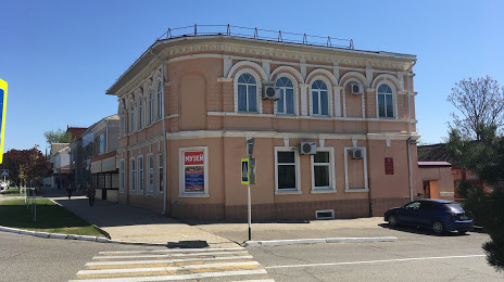
Temryukskiy Istoriko-Arkheologicheskiy Muzey on the map, Temryuk, Russian Federation
Photo
Where is located Temryukskiy Istoriko-Arkheologicheskiy Muzey
Temryukskiy Istoriko-Arkheologicheskiy Muzey — local attraction, which is located at Ulitsa Lenina, 28, Temryuk, Krasnodar Krai, 353504 and belongs to the category — archaeological museum. Average visitor rating for this place — 4.6 (according to 97 ratings, information from open sources and relevant for 2022).
Exact location — Temryukskiy Istoriko-Arkheologicheskiy Muzey, marked on the map with a red marker.
You can get directions to Temryukskiy Istoriko-Arkheologicheskiy Muzey on the map from your location.
What else is interesting in Temryuk? You can see all the sights if you go to the city page.
Coordinates
Temryukskiy Istoriko-Arkheologicheskiy Muzey, Russian Federation coordinates in decimal format: latitude — 45.281941381100445, longitude — 37.364500998076274. When converted to degrees, minutes, seconds Temryukskiy Istoriko-Arkheologicheskiy Muzey has the following coordinates: 45°16′54.99 north latitude and 37°21′52.2 east longitude.
Nearby cities
The largest cities that are located nearby:
- Novorossiysk — 68 km
- Kerch — 71 km
- Krasnodar — 128 km
- Berdyans'k
 — 171 km
 - Maykop — 226 km
- Melitopol' — 230 km
- Taganrog — 245 km
- Simferopol — 258 km
- Sochi — 265 km
- Bataysk — 273 km
- Donetsk — 306 km
- Sevastopol — 311 km
- Yevpatoriya — 312 km
- Novocherkassk — 313 km
- Nikopol'
 (Ukraine) — 337 km
 - Horlivka — 340 km
- Shakhty — 343 km
- Stavropol — 361 km
- Nevinnomyssk — 366 km
Distance to the capital
Distance to the capital (Moscow) is about — 1165 km.