
 Mikhaylovka
Dyrestuy
Mikhaylovka
Mayskiy
Novobessergenevka
Tersky District
Lesnoy
Tertezh
Kuz'minskiye Otverzhki
Mikhaylovka
Dyrestuy
Mikhaylovka
Mayskiy
Novobessergenevka
Tersky District
Lesnoy
Tertezh
Kuz'minskiye Otverzhki
Agurskiye Vodopady on the map, Adler, Russian Federation
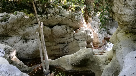
Photo
Where is located Agurskiye Vodopady
Agurskiye Vodopady — local attraction, which is located at 30 m and belongs to the category — -. Average visitor rating for this place — 4.5 (according to 41 rating, information from open sources and relevant for 2022).
Exact location — Agurskiye Vodopady, marked on the map with a red marker.
You can get directions to Agurskiye Vodopady on the map from your location.
What else is interesting in Adler? You can see all the sights if you go to the city page.
Coordinates
Agurskiye Vodopady, Russian Federation coordinates in decimal format: latitude — 43.55963338126779, longitude — 39.82576867510243. When converted to degrees, minutes, seconds Agurskiye Vodopady has the following coordinates: 43°33′34.68 north latitude and 39°49′32.77 east longitude.
Nearby cities
The largest cities that are located nearby:
- Sochi — 23 km
- Maykop — 130 km
- Cherkessk — 190 km
- Krasnodar — 192 km
- Nevinnomyssk — 207 km
- Novorossiysk — 222 km
- Kislovodsk — 229 km
- Stavropol — 241 km
- Batumi
 (Georgia) — 244 km
 - Pyatigorsk — 258 km
- Kutaisi (Georgia) — 263 km
- Trabzon
 (Turkey) — 269 km
 - Nalchik — 297 km
- Ordu (Turkey) — 320 km
- Kerch — 342 km
- Samsun (Turkey) — 380 km
- Vladikavkaz — 385 km
- Nazran — 392 km
- Erzurum (Turkey) — 406 km
Distance to the capital
Distance to the capital (Moscow) is about — 1366 km.