
 Mikhaylovka
Dyrestuy
Mikhaylovka
Mayskiy
Novobessergenevka
Tersky District
Lesnoy
Tertezh
Kuz'minskiye Otverzhki
Mikhaylovka
Dyrestuy
Mikhaylovka
Mayskiy
Novobessergenevka
Tersky District
Lesnoy
Tertezh
Kuz'minskiye Otverzhki
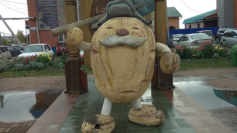
Pamyatnik Kartoshke on the map, Mariinsk, Russian Federation
Photo
Where is located Pamyatnik Kartoshke
Pamyatnik Kartoshke — local attraction, which is located at Kommunisticheskaya Ulitsa, 71, Mariinsk, Kemerovo Oblast, 652150 and belongs to the category — historical landmark. Average visitor rating for this place — 4.5 (according to 250 ratings, information from open sources and relevant for 2022).
Exact location — Pamyatnik Kartoshke, marked on the map with a red marker.
You can get directions to Pamyatnik Kartoshke on the map from your location.
What else is interesting in Mariinsk? You can see all the sights if you go to the city page.
Coordinates
Pamyatnik Kartoshke, Russian Federation coordinates in decimal format: latitude — 56.20604794337245, longitude — 87.7601911983147. When converted to degrees, minutes, seconds Pamyatnik Kartoshke has the following coordinates: 56°12′21.77 north latitude and 87°45′36.69 east longitude.
Nearby cities
The largest cities that are located nearby:
- Achinsk — 169 km
- Tomsk — 172 km
- Seversk — 182 km
- Leninsk-Kuznetskiy — 199 km
- Prokopyevsk — 265 km
- Novokuznetsk — 273 km
- Mezhdurechensk — 279 km
- Krasnoyarsk — 319 km
- Novosibirsk — 332 km
- Abakan — 365 km
- Barnaul — 410 km
- Biysk — 440 km
- Kansk — 490 km
- Kyzyl — 676 km
- Rubtsovsk — 686 km
- Oskemen
 (Kazakhstan) — 780 km
 - Nizhnevartovsk — 798 km
- Semey (Kazakhstan) — 829 km
- Pavlodar (Kazakhstan) — 848 km
Distance to the capital
Distance to the capital (Moscow) is about — 3051 km.