
 Mikhaylovka
Dyrestuy
Mikhaylovka
Mayskiy
Novobessergenevka
Tersky District
Lesnoy
Tertezh
Kuz'minskiye Otverzhki
Mikhaylovka
Dyrestuy
Mikhaylovka
Mayskiy
Novobessergenevka
Tersky District
Lesnoy
Tertezh
Kuz'minskiye Otverzhki
Bogoyavlenskiy Alanskiy Monastyr' on the map, Alagir, Russian Federation
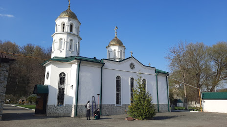
Photo
Where is located Bogoyavlenskiy Alanskiy Monastyr'
Bogoyavlenskiy Alanskiy Monastyr' — local attraction, which is located at Alagir, North Ossetia–Alania Republic, 363210 and belongs to the category — convent. Average visitor rating for this place — 4.9 (according to 107 ratings, information from open sources and relevant for 2022).
Exact location — Bogoyavlenskiy Alanskiy Monastyr', marked on the map with a red marker.
You can get directions to Bogoyavlenskiy Alanskiy Monastyr' on the map from your location.
What else is interesting in Alagir? You can see all the sights if you go to the city page.
Coordinates
Bogoyavlenskiy Alanskiy Monastyr', Russian Federation coordinates in decimal format: latitude — 42.98888623919735, longitude — 44.21481599784286. When converted to degrees, minutes, seconds Bogoyavlenskiy Alanskiy Monastyr' has the following coordinates: 42°59′19.99 north latitude and 44°12′53.34 east longitude.
Nearby cities
The largest cities that are located nearby:
- Vladikavkaz — 35 km
- Nazran — 48 km
- Nalchik — 69 km
- Pyatigorsk — 145 km
- Kutaisi
 (Georgia) — 152 km
 - Tbilisi (Georgia) — 153 km
- Kislovodsk — 154 km
- Khasavyurt — 192 km
- Cherkessk — 216 km
- Vanadzor
 (Armenia) — 248 km
 - Gyumri (Armenia) — 250 km
- Nevinnomyssk — 252 km
- Batumi (Georgia) — 264 km
- Makhachkala — 265 km
- Stavropol — 283 km
- Yerevan (Armenia) — 317 km
- Derbent — 352 km
- Elista — 362 km
- Sochi — 365 km
Distance to the capital
Distance to the capital (Moscow) is about — 1497 km.