
 Mikhaylovka
Dyrestuy
Mikhaylovka
Mayskiy
Novobessergenevka
Tersky District
Lesnoy
Tertezh
Kuz'minskiye Otverzhki
Mikhaylovka
Dyrestuy
Mikhaylovka
Mayskiy
Novobessergenevka
Tersky District
Lesnoy
Tertezh
Kuz'minskiye Otverzhki
Catherine Sloboda on the map, Ostashkov, Russian Federation
Photo
Where is located Catherine Sloboda
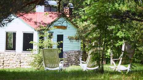
Catherine Sloboda — local attraction, which is located at Sloboda, Tver Oblast, 172751 and belongs to the category — travellers lodge. Average visitor rating for this place — 4.7 (according to 73 ratings, information from open sources and relevant for 2022).
Exact location — Catherine Sloboda, marked on the map with a red marker.
You can get directions to Catherine Sloboda on the map from your location.
What else is interesting in Ostashkov? You can see all the sights if you go to the city page.
Coordinates
Catherine Sloboda, Russian Federation coordinates in decimal format: latitude — 57.18544451002566, longitude — 33.025916998353196. When converted to degrees, minutes, seconds Catherine Sloboda has the following coordinates: 57°11′7.6 north latitude and 33°1′33.3 east longitude.
Nearby cities
The largest cities that are located nearby:
- Tver — 171 km
- Velikiye Luki — 182 km
- Smolensk — 269 km
- Zelenograd — 281 km
- Pskov — 292 km
- Khimki — 301 km
- Odintsovo — 305 km
- Obninsk — 313 km
- Pushkino — 317 km
- Kolpino — 319 km
- Izmaylovo — 332 km
- Balashikha — 334 km
- Podolsk — 335 km
- Navapolatsk
 (Belarus) — 338 km
 - Lyubertsy — 338 km
- Saint Petersburg — 345 km
- Rybinsk — 349 km
- Cherepovets — 349 km
- Kaluga — 351 km
Distance to the capital
Distance to the capital (Moscow) is about — 324 km.